|
|
|||||||||||||||||
| Point ID: 7301 | Downloads | Plots | Site Data | Other Close Sites | Code: 49078 |
|
|
|||||||||||||||||
| Download | |
|---|---|
| Site Descriptor Information | Site Time Series Data |
| Link to all available data | |
| View: | Time Series | All |
| Units: | mm |
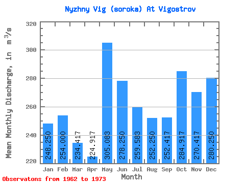
| Statistic | Jan | Feb | Mar | Apr | May | Jun | Jul | Aug | Sep | Oct | Nov | Dec | Annual |
|---|---|---|---|---|---|---|---|---|---|---|---|---|---|
| Mean | 248.25 | 254.00 | 234.42 | 224.92 | 305.08 | 278.25 | 259.58 | 252.25 | 252.42 | 284.92 | 270.42 | 280.25 | 262.06 |
| Standard Deviation | 48.43 | 49.26 | 49.11 | 69.68 | 74.06 | 62.39 | 143.68 | 134.27 | 91.05 | 80.30 | 70.36 | 34.03 | 51.35 |
| Min | 182.00 | 189.00 | 178.00 | 166.00 | 193.00 | 196.00 | 190.00 | 153.00 | 152.00 | 216.00 | 215.00 | 229.00 | 214.75 |
| Max | 369.00 | 380.00 | 352.00 | 423.00 | 421.00 | 368.00 | 709.00 | 668.00 | 515.00 | 503.00 | 477.00 | 357.00 | 411.50 |
| Coefficient of Variation | 0.20 | 0.19 | 0.21 | 0.31 | 0.24 | 0.22 | 0.55 | 0.53 | 0.36 | 0.28 | 0.26 | 0.12 | 0.20 |
| Other Close Sites | ||||||
|---|---|---|---|---|---|---|
| PointID | Latitude | Longitude | Drainage Area | Source | Name | |
| 7300 | "Belomorkanal At Matkozh" | 64.43 | -2323887 | SHI | 21.00 | |
| 7302 | "Nyzhny Vig (Soroka) At Belomorskaya" | 64.52 | -2310273 | SHI | 5.50 | |
 Return to R-Arctic Net Home Page