|
|
| Point ID: 7301 | Downloads | Plots | Site Data | Other Close Sites | Code: 49078 |
|
| Download | |
|---|---|
| Site Descriptor Information | Site Time Series Data |
| Link to all available data | |
|
|
|
| View: | Statistics | All |
| Units: | mm |
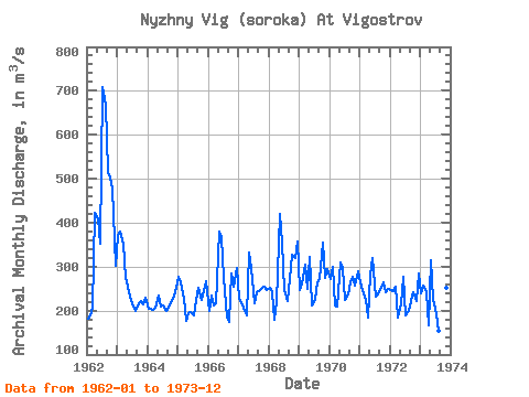
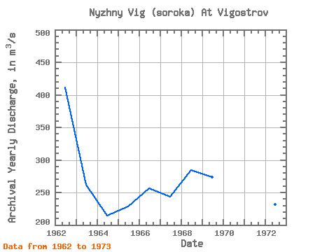
| Year | Jan | Feb | Mar | Apr | May | Jun | Jul | Aug | Sep | Oct | Nov | Dec | Annual | 1962 | 182.00 | 189.00 | 206.00 | 423.00 | 410.00 | 353.00 | 709.00 | 668.00 | 515.00 | 503.00 | 477.00 | 303.00 | 411.50 | 1963 | 369.00 | 380.00 | 352.00 | 274.00 | 254.00 | 232.00 | 208.00 | 199.00 | 211.00 | 222.00 | 215.00 | 229.00 | 262.08 | 1964 | 204.00 | 205.00 | 202.00 | 206.00 | 233.00 | 208.00 | 211.00 | 200.00 | 206.00 | 216.00 | 234.00 | 252.00 | 214.75 | 1965 | 278.00 | 265.00 | 227.00 | 176.00 | 193.00 | 196.00 | 190.00 | 223.00 | 251.00 | 225.00 | 244.00 | 268.00 | 228.00 | 1966 | 198.00 | 233.00 | 212.00 | 217.00 | 379.00 | 368.00 | 275.00 | 183.00 | 173.00 | 284.00 | 255.00 | 298.00 | 256.25 | 1967 | 226.00 | 220.00 | 200.00 | 190.00 | 331.00 | 296.00 | 217.00 | 242.00 | 244.00 | 251.00 | 254.00 | 248.00 | 243.25 | 1968 | 252.00 | 242.00 | 178.00 | 220.00 | 421.00 | 355.00 | 247.00 | 222.00 | 273.00 | 326.00 | 320.00 | 357.00 | 284.42 | 1969 | 247.00 | 263.00 | 304.00 | 250.00 | 322.00 | 212.00 | 223.00 | 264.00 | 271.00 | 355.00 | 274.00 | 295.00 | 273.33 | 1970 | 273.00 | 300.00 | 211.00 | 209.00 | 309.00 | 297.00 | 223.00 | 236.00 | 264.00 | 278.00 | 257.00 | 290.00 | 262.25 | 1971 | 264.00 | 248.00 | 225.00 | 185.00 | 282.00 | 319.00 | 231.00 | 237.00 | 248.00 | 264.00 | 242.00 | 249.00 | 249.50 | 1972 | 247.00 | 245.00 | 254.00 | 183.00 | 213.00 | 277.00 | 190.00 | 200.00 | 221.00 | 243.00 | 222.00 | 284.00 | 231.58 | 1973 | 239.00 | 258.00 | 242.00 | 166.00 | 314.00 | 226.00 | 191.00 | 153.00 | 152.00 | 252.00 | 251.00 | 290.00 | 227.83 |
|---|
| Other Close Sites | ||||||
|---|---|---|---|---|---|---|
| PointID | Latitude | Longitude | Drainage Area | Source | Name | |
| 7300 | "Belomorkanal At Matkozh" | 64.43 | -2323887 | SHI | 21.00 | |
| 7302 | "Nyzhny Vig (Soroka) At Belomorskaya" | 64.52 | -2310273 | SHI | 5.50 | |
 Return to R-Arctic Net Home Page