|
|
|||||||||||||||||
| Point ID: 7301 | Downloads | Plots | Site Data | Other Close Sites | Code: 49078 |
|
|
|||||||||||||||||
| Download | |
|---|---|
| Site Descriptor Information | Site Time Series Data |
| Link to all available data | |
| View: | Time Series | All |
| Units: | m3/s |
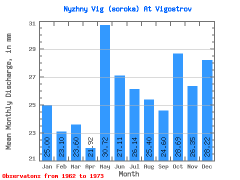
| Statistic | Jan | Feb | Mar | Apr | May | Jun | Jul | Aug | Sep | Oct | Nov | Dec | Annual |
|---|---|---|---|---|---|---|---|---|---|---|---|---|---|
| Mean | 24.99 | 23.30 | 23.60 | 21.92 | 30.71 | 27.11 | 26.13 | 25.40 | 24.60 | 28.68 | 26.35 | 28.21 | 310.93 |
| Standard Deviation | 4.88 | 4.52 | 4.94 | 6.79 | 7.46 | 6.08 | 14.46 | 13.52 | 8.87 | 8.09 | 6.86 | 3.43 | 60.92 |
| Min | 18.32 | 17.34 | 17.92 | 16.18 | 19.43 | 19.10 | 19.13 | 15.40 | 14.81 | 21.75 | 20.95 | 23.05 | 254.79 |
| Max | 37.15 | 34.86 | 35.44 | 41.22 | 42.38 | 35.86 | 71.38 | 67.25 | 50.18 | 50.64 | 46.48 | 35.94 | 488.23 |
| Coefficient of Variation | 0.20 | 0.19 | 0.21 | 0.31 | 0.24 | 0.22 | 0.55 | 0.53 | 0.36 | 0.28 | 0.26 | 0.12 | 0.20 |
| Other Close Sites | ||||||
|---|---|---|---|---|---|---|
| PointID | Latitude | Longitude | Drainage Area | Source | Name | |
| 7300 | "Belomorkanal At Matkozh" | 64.43 | -2323887 | SHI | 21.00 | |
| 7302 | "Nyzhny Vig (Soroka) At Belomorskaya" | 64.52 | -2310273 | SHI | 5.50 | |
 Return to R-Arctic Net Home Page