|
|
|||||||||||||||||
| Point ID: 7302 | Downloads | Plots | Site Data | Other Close Sites | Code: 49081 |
|
|
|||||||||||||||||
| Download | |
|---|---|
| Site Descriptor Information | Site Time Series Data |
| Link to all available data | |
| View: | Time Series | All |
| Units: | mm |
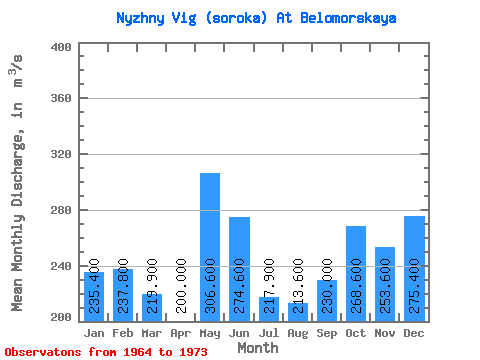
| Statistic | Jan | Feb | Mar | Apr | May | Jun | Jul | Aug | Sep | Oct | Nov | Dec | Annual |
|---|---|---|---|---|---|---|---|---|---|---|---|---|---|
| Mean | 235.40 | 237.80 | 219.90 | 200.00 | 306.60 | 274.60 | 217.90 | 213.60 | 230.00 | 268.60 | 253.60 | 275.40 | 244.45 |
| Standard Deviation | 31.26 | 30.80 | 38.62 | 22.19 | 68.50 | 61.58 | 30.40 | 32.83 | 44.42 | 46.25 | 26.88 | 33.27 | 24.15 |
| Min | 180.00 | 194.00 | 166.00 | 170.00 | 189.00 | 188.00 | 182.00 | 158.00 | 158.00 | 206.00 | 226.00 | 232.00 | 207.08 |
| Max | 274.00 | 296.00 | 301.00 | 251.00 | 406.00 | 368.00 | 274.00 | 261.00 | 281.00 | 365.00 | 317.00 | 350.00 | 278.67 |
| Coefficient of Variation | 0.13 | 0.13 | 0.18 | 0.11 | 0.22 | 0.22 | 0.14 | 0.15 | 0.19 | 0.17 | 0.11 | 0.12 | 0.10 |
| Other Close Sites | ||||||
|---|---|---|---|---|---|---|
| PointID | Latitude | Longitude | Drainage Area | Source | Name | |
| 7300 | "Belomorkanal At Matkozh" | 64.43 | -2323887 | SHI | 21.00 | |
| 7301 | "Nyzhny Vig (Soroka) At Vigostrov" | 64.48 | -2314678 | SHI | 11.00 | |
 Return to R-Arctic Net Home Page