|
|
|||||||||||||||||
| Point ID: 9555 | Downloads | Plots | Site Data | Code: 05060550 |
|
|
|||||||||||||||||
| Download | |
|---|---|
| Site Descriptor Information | Site Time Series Data |
| Link to all available data | |
| View: | Time Series | All |
| Units: | mm |
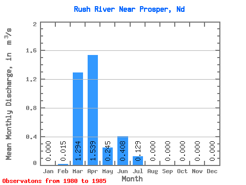
| Statistic | Jan | Feb | Mar | Apr | May | Jun | Jul | Aug | Sep | Oct | Nov | Dec | Annual |
|---|---|---|---|---|---|---|---|---|---|---|---|---|---|
| Mean | 0.00 | 0.01 | 1.29 | 1.54 | 0.24 | 0.41 | 0.13 | 0.00 | 0.00 | 0.00 | 0.00 | 0.00 | |
| Standard Deviation | 1.43 | 2.29 | 0.25 | 0.44 | 0.24 | 0.00 | |||||||
| Min | 0.00 | 0.01 | 0.04 | 0.01 | 0.01 | 0.03 | 0.00 | 0.00 | 0.00 | 0.00 | 0.00 | 0.00 | |
| Max | 0.00 | 0.01 | 3.60 | 5.54 | 0.63 | 0.96 | 0.56 | 0.00 | 0.00 | 0.00 | 0.00 | 0.00 | |
| Coefficient of Variation | 1.10 | 1.49 | 1.00 | 1.07 | 1.86 |
 Return to R-Arctic Net Home Page