|
|
| Point ID: 9555 | Downloads | Plots | Site Data | Code: 05060550 |
|
| Download | |
|---|---|
| Site Descriptor Information | Site Time Series Data |
| Link to all available data | |
|
|
|
| View: | Statistics | All |
| Units: | mm |
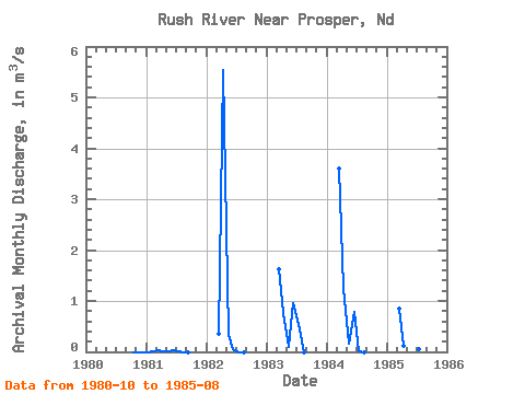
| Year | Jan | Feb | Mar | Apr | May | Jun | Jul | Aug | Sep | Oct | Nov | Dec | Annual | 1980 | 0.00 | 0.00 | 0.00 | 1981 | 0.00 | 0.01 | 0.04 | 0.01 | 0.01 | 0.03 | 0.00 | 0.00 | 0.00 | 1982 | 0.35 | 5.54 | 0.34 | 0.06 | 0.00 | 0.00 | 1983 | 1.62 | 0.76 | 0.09 | 0.96 | 0.56 | 0.00 | 1984 | 3.60 | 1.27 | 0.16 | 0.79 | 0.02 | 0.00 | 1985 | 0.85 | 0.12 | 0.63 | 0.20 | 0.06 | 0.00 |
|---|
 Return to R-Arctic Net Home Page