|
|
|||||||||||||||||
| Point ID: 9555 | Downloads | Plots | Site Data | Code: 05060550 |
|
|
|||||||||||||||||
| Download | |
|---|---|
| Site Descriptor Information | Site Time Series Data |
| Link to all available data | |
| View: | Time Series | All |
| Units: | m3/s |
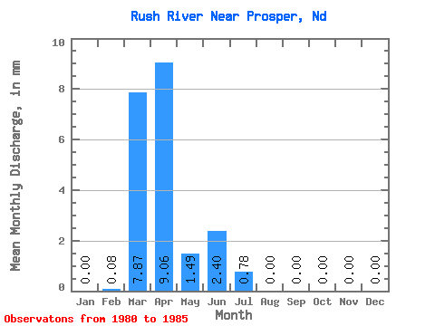
| Statistic | Jan | Feb | Mar | Apr | May | Jun | Jul | Aug | Sep | Oct | Nov | Dec | Annual |
|---|---|---|---|---|---|---|---|---|---|---|---|---|---|
| Mean | 0.00 | 0.08 | 7.87 | 9.06 | 1.49 | 2.40 | 0.79 | 0.00 | 0.00 | 0.00 | 0.00 | 0.00 | |
| Standard Deviation | 8.66 | 13.50 | 1.50 | 2.58 | 1.47 | 0.00 | |||||||
| Min | 0.00 | 0.08 | 0.21 | 0.07 | 0.04 | 0.17 | 0.00 | 0.00 | 0.00 | 0.00 | 0.00 | 0.00 | |
| Max | 0.00 | 0.08 | 21.93 | 32.61 | 3.81 | 5.67 | 3.39 | 0.00 | 0.00 | 0.00 | 0.00 | 0.00 | |
| Coefficient of Variation | 1.10 | 1.49 | 1.00 | 1.07 | 1.86 |
 Return to R-Arctic Net Home Page