|
|
|||||||||||||||||
| Point ID: 8880 | Downloads | Plots | Site Data | Code: 70482 |
|
|
|||||||||||||||||
| Download | |
|---|---|
| Site Descriptor Information | Site Time Series Data |
| Link to all available data | |
| View: | Time Series | All |
| Units: | mm |
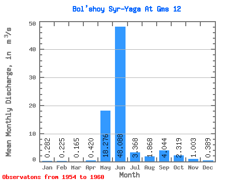
| Statistic | Jan | Feb | Mar | Apr | May | Jun | Jul | Aug | Sep | Oct | Nov | Dec | Annual |
|---|---|---|---|---|---|---|---|---|---|---|---|---|---|
| Mean | 0.28 | 0.23 | 0.17 | 0.42 | 18.28 | 48.09 | 3.37 | 1.87 | 4.04 | 2.32 | 1.00 | 0.39 | 5.36 |
| Standard Deviation | 0.22 | 0.01 | 0.06 | 0.35 | 14.75 | 27.84 | 1.16 | 1.39 | 1.77 | 1.17 | 0.52 | 0.36 | 0.45 |
| Min | 0.09 | 0.22 | 0.12 | 0.11 | 1.89 | 7.23 | 2.07 | 1.14 | 1.90 | 1.46 | 0.60 | 0.05 | 5.04 |
| Max | 0.56 | 0.23 | 0.21 | 0.80 | 35.80 | 79.20 | 5.05 | 4.69 | 6.48 | 4.65 | 1.97 | 0.80 | 5.68 |
| Coefficient of Variation | 0.78 | 0.03 | 0.39 | 0.83 | 0.81 | 0.58 | 0.34 | 0.74 | 0.44 | 0.51 | 0.52 | 0.93 | 0.08 |
 Return to R-Arctic Net Home Page