|
|
|||||||||||||||||
| Point ID: 8880 | Downloads | Plots | Site Data | Code: 70482 |
|
|
|||||||||||||||||
| Download | |
|---|---|
| Site Descriptor Information | Site Time Series Data |
| Link to all available data | |
| View: | Time Series | All |
| Units: | m3/s |
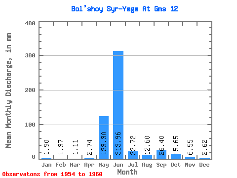
| Statistic | Jan | Feb | Mar | Apr | May | Jun | Jul | Aug | Sep | Oct | Nov | Dec | Annual |
|---|---|---|---|---|---|---|---|---|---|---|---|---|---|
| Mean | 1.90 | 1.38 | 1.11 | 2.74 | 123.28 | 313.97 | 22.72 | 12.60 | 26.40 | 15.64 | 6.55 | 2.63 | 426.10 |
| Standard Deviation | 1.47 | 0.04 | 0.43 | 2.29 | 99.50 | 181.79 | 7.85 | 9.39 | 11.57 | 7.92 | 3.37 | 2.44 | 35.79 |
| Min | 0.61 | 1.35 | 0.81 | 0.72 | 12.75 | 47.20 | 13.96 | 7.69 | 12.40 | 9.85 | 3.92 | 0.32 | 400.79 |
| Max | 3.78 | 1.41 | 1.42 | 5.22 | 241.49 | 517.09 | 34.06 | 31.64 | 42.31 | 31.37 | 12.86 | 5.40 | 451.41 |
| Coefficient of Variation | 0.78 | 0.03 | 0.39 | 0.83 | 0.81 | 0.58 | 0.34 | 0.74 | 0.44 | 0.51 | 0.52 | 0.93 | 0.08 |
 Return to R-Arctic Net Home Page