|
|
| Point ID: 8880 | Downloads | Plots | Site Data | Code: 70482 |
|
| Download | |
|---|---|
| Site Descriptor Information | Site Time Series Data |
| Link to all available data | |
|
|
|
| View: | Statistics | All |
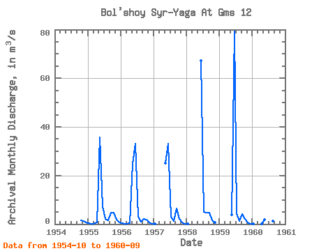
| Units: | mm |
| Year | Jan | Feb | Mar | Apr | May | Jun | Jul | Aug | Sep | Oct | Nov | Dec | Annual | 1954 | 1.63 | 1.16 | 0.80 | 1955 | 0.47 | 0.23 | 0.12 | 0.80 | 35.80 | 7.23 | 2.07 | 1.59 | 4.81 | 4.65 | 1.97 | 0.76 | 5.04 | 1956 | 0.56 | 0.22 | 0.21 | 0.35 | 24.80 | 33.20 | 2.96 | 1.14 | 2.04 | 1.92 | 0.60 | 0.14 | 5.68 | 1957 | 0.09 | 25.00 | 33.00 | 3.01 | 1.24 | 6.48 | 2.19 | 0.60 | 0.20 | 1958 | 0.10 | 67.30 | 5.05 | 4.69 | 4.77 | 1.46 | 0.84 | 1959 | 3.89 | 79.20 | 4.53 | 1.19 | 4.26 | 2.06 | 0.85 | 0.05 | 1960 | 0.19 | 0.11 | 1.89 | 68.60 | 2.59 | 1.36 | 1.90 |
|---|
 Return to R-Arctic Net Home Page