|
|
|||||||||||||||||
| Point ID: 7695 | Downloads | Plots | Site Data | Code: 15389000 |
|
|
|||||||||||||||||
| Download | |
|---|---|
| Site Descriptor Information | Site Time Series Data |
| Link to all available data | |
| View: | Time Series | All |
| Units: | mm |
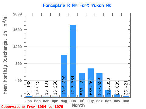
| Statistic | Jan | Feb | Mar | Apr | May | Jun | Jul | Aug | Sep | Oct | Nov | Dec | Annual |
|---|---|---|---|---|---|---|---|---|---|---|---|---|---|
| Mean | 24.13 | 19.01 | 16.10 | 16.26 | 1009.33 | 1719.98 | 583.13 | 685.26 | 567.63 | 185.85 | 65.69 | 35.42 | 413.79 |
| Standard Deviation | 10.18 | 9.81 | 9.11 | 7.46 | 710.99 | 685.50 | 222.72 | 398.52 | 263.35 | 91.74 | 33.31 | 13.60 | 105.06 |
| Min | 5.38 | 1.02 | 0.00 | 2.83 | 58.36 | 563.79 | 169.79 | 154.01 | 147.30 | 57.85 | 25.48 | 10.96 | 248.89 |
| Max | 36.64 | 31.15 | 26.76 | 25.97 | 2406.08 | 2826.02 | 1045.74 | 1258.68 | 1206.86 | 392.75 | 122.70 | 58.64 | 607.00 |
| Coefficient of Variation | 0.42 | 0.52 | 0.57 | 0.46 | 0.70 | 0.40 | 0.38 | 0.58 | 0.46 | 0.49 | 0.51 | 0.38 | 0.25 |
 Return to R-Arctic Net Home Page