|
|
|||||||||||||||||
| Point ID: 7695 | Downloads | Plots | Site Data | Code: 15389000 |
|
|
|||||||||||||||||
| Download | |
|---|---|
| Site Descriptor Information | Site Time Series Data |
| Link to all available data | |
| View: | Time Series | All |
| Units: | m3/s |
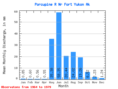
| Statistic | Jan | Feb | Mar | Apr | May | Jun | Jul | Aug | Sep | Oct | Nov | Dec | Annual |
|---|---|---|---|---|---|---|---|---|---|---|---|---|---|
| Mean | 0.85 | 0.61 | 0.56 | 0.55 | 35.38 | 58.35 | 20.44 | 24.02 | 19.26 | 6.51 | 2.23 | 1.24 | 170.92 |
| Standard Deviation | 0.36 | 0.31 | 0.32 | 0.25 | 24.92 | 23.25 | 7.81 | 13.97 | 8.93 | 3.21 | 1.13 | 0.48 | 43.40 |
| Min | 0.19 | 0.03 | 0.00 | 0.10 | 2.05 | 19.13 | 5.95 | 5.40 | 5.00 | 2.03 | 0.86 | 0.38 | 102.81 |
| Max | 1.28 | 0.99 | 0.94 | 0.88 | 84.33 | 95.87 | 36.65 | 44.12 | 40.94 | 13.77 | 4.16 | 2.06 | 250.73 |
| Coefficient of Variation | 0.42 | 0.52 | 0.57 | 0.46 | 0.70 | 0.40 | 0.38 | 0.58 | 0.46 | 0.49 | 0.51 | 0.38 | 0.25 |
 Return to R-Arctic Net Home Page