|
|
| Point ID: 7695 | Downloads | Plots | Site Data | Code: 15389000 |
|
| Download | |
|---|---|
| Site Descriptor Information | Site Time Series Data |
| Link to all available data | |
|
|
|
| View: | Statistics | All |
| Units: | mm |
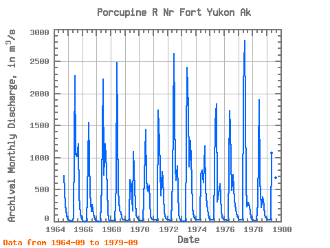
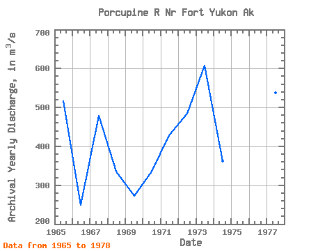
| Year | Jan | Feb | Mar | Apr | May | Jun | Jul | Aug | Sep | Oct | Nov | Dec | Annual | 1964 | 712.74 | 257.40 | 104.77 | 45.31 | 1965 | 31.15 | 11.33 | 3.40 | 2.83 | 58.36 | 2271.01 | 1045.74 | 1017.71 | 1206.86 | 392.75 | 110.44 | 39.64 | 515.93 | 1966 | 6.80 | 1.02 | 0.00 | 9.06 | 413.71 | 1541.57 | 436.36 | 154.01 | 261.02 | 116.72 | 35.40 | 10.96 | 248.89 | 1967 | 5.38 | 1.08 | 0.00 | 3.68 | 547.08 | 2216.08 | 726.33 | 1214.51 | 811.00 | 170.30 | 30.95 | 19.96 | 478.86 | 1968 | 17.36 | 16.03 | 14.61 | 14.16 | 587.01 | 2476.88 | 466.10 | 161.60 | 147.30 | 57.85 | 30.02 | 26.76 | 334.64 | 1969 | 24.15 | 21.35 | 19.82 | 22.31 | 655.53 | 563.79 | 169.79 | 1096.14 | 502.91 | 100.67 | 48.62 | 41.48 | 272.21 | 1970 | 26.22 | 20.08 | 19.82 | 19.82 | 688.10 | 1433.68 | 626.65 | 476.57 | 569.17 | 72.46 | 47.77 | 33.61 | 336.16 | 1971 | 24.72 | 23.22 | 22.37 | 21.24 | 1739.50 | 1241.98 | 407.20 | 780.98 | 656.67 | 137.65 | 44.37 | 32.99 | 427.74 | 1972 | 29.68 | 26.45 | 21.18 | 16.23 | 620.99 | 2623.56 | 828.55 | 639.96 | 868.48 | 101.29 | 25.48 | 14.81 | 484.72 | 1973 | 9.18 | 7.08 | 7.08 | 7.08 | 2406.08 | 1780.00 | 850.36 | 1258.68 | 645.62 | 209.18 | 68.44 | 35.17 | 607.00 | 1974 | 28.32 | 25.48 | 22.65 | 22.65 | 731.99 | 801.37 | 608.53 | 1177.41 | 502.62 | 265.81 | 109.95 | 48.88 | 362.14 | 1975 | 34.43 | 31.15 | 26.76 | 25.97 | 1544.12 | 1831.82 | 308.65 | 439.76 | 585.88 | 166.16 | 60.51 | 34.89 | 424.18 | 1976 | 27.78 | 23.53 | 19.28 | 17.93 | 1723.93 | 1448.97 | 494.41 | 728.88 | 326.49 | 257.14 | 122.70 | 58.64 | 437.47 | 1977 | 36.36 | 29.34 | 25.03 | 23.30 | 2081.29 | 2826.02 | 589.56 | 232.37 | 298.46 | 227.64 | 56.07 | 33.67 | 538.26 | 1978 | 23.81 | 19.23 | 15.74 | 15.26 | 276.63 | 1901.19 | 645.34 | 222.17 | 379.73 | 254.77 | 89.85 | 54.54 | 324.86 | 1979 | 36.64 | 28.83 | 23.76 | 22.31 | 1065.56 | 841.86 | 543.40 | 678.19 | 607.11 |
|---|
 Return to R-Arctic Net Home Page