|
|
|||||||||||||||||
| Point ID: 7137 | Downloads | Plots | Site Data | Code: 11664 |
|
|
|||||||||||||||||
| Download | |
|---|---|
| Site Descriptor Information | Site Time Series Data |
| Link to all available data | |
| View: | Time Series | All |
| Units: | mm |
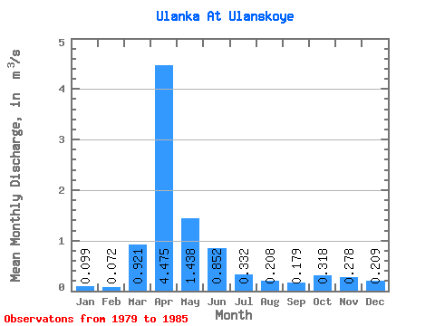
| Statistic | Jan | Feb | Mar | Apr | May | Jun | Jul | Aug | Sep | Oct | Nov | Dec | Annual |
|---|---|---|---|---|---|---|---|---|---|---|---|---|---|
| Mean | 0.10 | 0.07 | 0.92 | 4.47 | 1.44 | 0.85 | 0.33 | 0.21 | 0.18 | 0.32 | 0.28 | 0.21 | 0.78 |
| Standard Deviation | 0.08 | 0.08 | 0.83 | 3.50 | 0.72 | 0.87 | 0.33 | 0.21 | 0.20 | 0.41 | 0.26 | 0.15 | 0.43 |
| Min | 0.03 | 0.00 | 0.04 | 0.52 | 0.62 | 0.12 | 0.01 | 0.01 | 0.01 | 0.04 | 0.07 | 0.03 | 0.41 |
| Max | 0.23 | 0.22 | 2.45 | 10.70 | 2.58 | 2.51 | 0.86 | 0.53 | 0.47 | 1.04 | 0.66 | 0.43 | 1.50 |
| Coefficient of Variation | 0.80 | 1.10 | 0.90 | 0.78 | 0.50 | 1.02 | 0.99 | 1.00 | 1.09 | 1.28 | 0.94 | 0.73 | 0.56 |
 Return to R-Arctic Net Home Page