|
|
| Point ID: 7137 | Downloads | Plots | Site Data | Code: 11664 |
|
| Download | |
|---|---|
| Site Descriptor Information | Site Time Series Data |
| Link to all available data | |
|
|
|
| View: | Statistics | All |
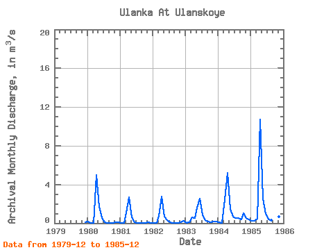
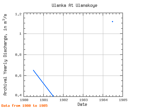
| Units: | mm |
| Year | Jan | Feb | Mar | Apr | May | Jun | Jul | Aug | Sep | Oct | Nov | Dec | Annual | 1979 | 0.09 | 1980 | 0.15 | 0.03 | 0.04 | 4.98 | 1.66 | 0.52 | 0.11 | 0.04 | 0.03 | 0.04 | 0.07 | 0.14 | 0.65 | 1981 | 0.05 | 0.03 | 1.14 | 2.68 | 0.62 | 0.12 | 0.01 | 0.01 | 0.01 | 0.07 | 0.08 | 0.03 | 0.41 | 1982 | 0.03 | 0.06 | 0.77 | 2.78 | 0.69 | 0.29 | 0.08 | 0.04 | 0.03 | 0.06 | 0.14 | 0.22 | 0.43 | 1983 | 0.04 | 0.09 | 0.63 | 0.52 | 1.61 | 2.51 | 0.86 | 0.29 | 0.17 | 0.13 | 0.16 | 0.15 | 0.60 | 1984 | 0.10 | 0.00 | 2.45 | 5.19 | 1.47 | 0.68 | 0.55 | 0.53 | 0.36 | 1.04 | 0.56 | 0.43 | 1.11 | 1985 | 0.23 | 0.22 | 0.49 | 10.70 | 2.58 | 0.99 | 0.38 | 0.33 | 0.47 | 0.57 | 0.66 | 0.40 | 1.50 |
|---|
 Return to R-Arctic Net Home Page