|
|
|||||||||||||||||
| Point ID: 7137 | Downloads | Plots | Site Data | Code: 11664 |
|
|
|||||||||||||||||
| Download | |
|---|---|
| Site Descriptor Information | Site Time Series Data |
| Link to all available data | |
| View: | Time Series | All |
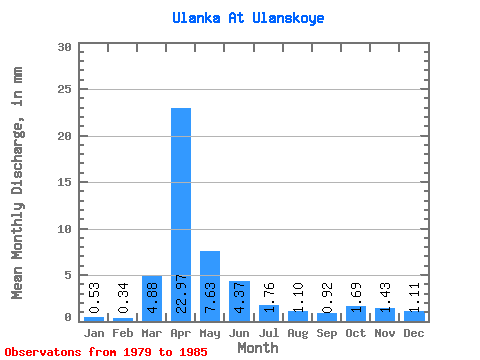
| Units: | m3/s |
| Statistic | Jan | Feb | Mar | Apr | May | Jun | Jul | Aug | Sep | Oct | Nov | Dec | Annual |
|---|---|---|---|---|---|---|---|---|---|---|---|---|---|
| Mean | 0.53 | 0.34 | 4.88 | 22.97 | 7.63 | 4.37 | 1.76 | 1.10 | 0.92 | 1.69 | 1.43 | 1.11 | 48.95 |
| Standard Deviation | 0.42 | 0.38 | 4.41 | 17.96 | 3.83 | 4.45 | 1.75 | 1.11 | 1.00 | 2.16 | 1.34 | 0.81 | 27.16 |
| Min | 0.13 | 0.01 | 0.23 | 2.67 | 3.29 | 0.62 | 0.07 | 0.07 | 0.07 | 0.19 | 0.37 | 0.15 | 25.31 |
| Max | 1.22 | 1.06 | 12.99 | 54.92 | 13.68 | 12.88 | 4.56 | 2.81 | 2.41 | 5.51 | 3.39 | 2.28 | 93.85 |
| Coefficient of Variation | 0.80 | 1.10 | 0.90 | 0.78 | 0.50 | 1.02 | 0.99 | 1.00 | 1.09 | 1.28 | 0.94 | 0.73 | 0.56 |
 Return to R-Arctic Net Home Page