|
|
|||||||||||||||||
| Point ID: 6656 | Downloads | Plots | Site Data | Code: 9803 |
|
|
|||||||||||||||||
| Download | |
|---|---|
| Site Descriptor Information | Site Time Series Data |
| Link to all available data | |
| View: | Time Series | All |
| Units: | mm |
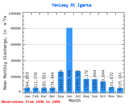
| Statistic | Jan | Feb | Mar | Apr | May | Jun | Jul | Aug | Sep | Oct | Nov | Dec | Annual |
|---|---|---|---|---|---|---|---|---|---|---|---|---|---|
| Mean | 6264.86 | 6311.08 | 6183.53 | 6274.34 | 26412.84 | 80928.41 | 26959.92 | 17340.17 | 16950.84 | 13993.84 | 7101.67 | 6019.14 | 18395.06 |
| Standard Deviation | 1690.78 | 1968.65 | 2198.78 | 2553.08 | 14240.54 | 14423.17 | 5284.56 | 3390.45 | 2706.74 | 2431.10 | 1843.13 | 1575.48 | 1346.10 |
| Min | 4000.00 | 3770.00 | 3380.00 | 3120.00 | 6180.00 | 39200.00 | 17768.00 | 12009.00 | 11400.00 | 8289.00 | 4640.00 | 4200.00 | 15649.17 |
| Max | 10800.00 | 11300.00 | 11600.00 | 11800.00 | 70000.00 | 119000.00 | 38500.00 | 25600.00 | 23800.00 | 20800.00 | 12300.00 | 11800.00 | 21424.17 |
| Coefficient of Variation | 0.27 | 0.31 | 0.36 | 0.41 | 0.54 | 0.18 | 0.20 | 0.20 | 0.16 | 0.17 | 0.26 | 0.26 | 0.07 |
 Return to R-Arctic Net Home Page