|
|
|||||||||||||||||
| Point ID: 6656 | Downloads | Plots | Site Data | Code: 9803 |
|
|
|||||||||||||||||
| Download | |
|---|---|
| Site Descriptor Information | Site Time Series Data |
| Link to all available data | |
| View: | Time Series | All |
| Units: | m3/s |
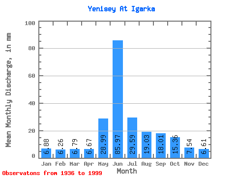
| Statistic | Jan | Feb | Mar | Apr | May | Jun | Jul | Aug | Sep | Oct | Nov | Dec | Annual |
|---|---|---|---|---|---|---|---|---|---|---|---|---|---|
| Mean | 6.88 | 6.31 | 6.79 | 6.67 | 28.99 | 85.97 | 29.59 | 19.03 | 18.01 | 15.36 | 7.54 | 6.61 | 237.93 |
| Standard Deviation | 1.86 | 1.97 | 2.41 | 2.71 | 15.63 | 15.32 | 5.80 | 3.72 | 2.88 | 2.67 | 1.96 | 1.73 | 17.41 |
| Min | 4.39 | 3.77 | 3.71 | 3.31 | 6.78 | 41.64 | 19.50 | 13.18 | 12.11 | 9.10 | 4.93 | 4.61 | 202.41 |
| Max | 11.85 | 11.30 | 12.73 | 12.54 | 76.83 | 126.41 | 42.26 | 28.10 | 25.28 | 22.83 | 13.07 | 12.95 | 277.11 |
| Coefficient of Variation | 0.27 | 0.31 | 0.36 | 0.41 | 0.54 | 0.18 | 0.20 | 0.20 | 0.16 | 0.17 | 0.26 | 0.26 | 0.07 |
 Return to R-Arctic Net Home Page