|
|
|||||||||||||||||
| Point ID: 5784 | Downloads | Plots | Site Data | Code: 09AA009 |
|
|
|||||||||||||||||
| Download | |
|---|---|
| Site Descriptor Information | Site Time Series Data |
| Link to all available data | |
| View: | Time Series | All |
| Units: | mm |
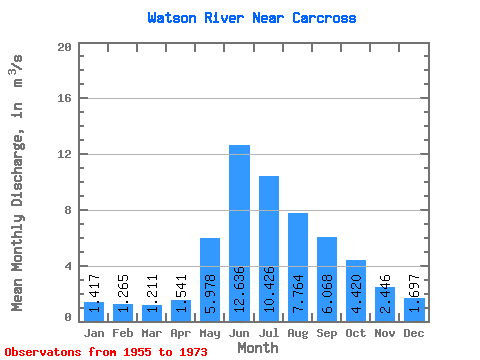
| Statistic | Jan | Feb | Mar | Apr | May | Jun | Jul | Aug | Sep | Oct | Nov | Dec | Annual |
|---|---|---|---|---|---|---|---|---|---|---|---|---|---|
| Mean | 1.42 | 1.27 | 1.21 | 1.54 | 5.98 | 12.64 | 10.43 | 7.76 | 6.07 | 4.42 | 2.45 | 1.70 | 5.09 |
| Standard Deviation | 0.42 | 0.42 | 0.44 | 0.52 | 2.09 | 4.00 | 2.62 | 2.14 | 2.43 | 1.39 | 0.66 | 0.41 | 0.66 |
| Min | 0.54 | 0.39 | 0.30 | 0.69 | 2.80 | 7.59 | 3.66 | 3.38 | 1.39 | 1.93 | 1.09 | 0.71 | 4.02 |
| Max | 1.88 | 1.87 | 1.92 | 2.29 | 8.69 | 19.10 | 14.20 | 11.30 | 11.10 | 6.89 | 3.30 | 2.19 | 5.77 |
| Coefficient of Variation | 0.30 | 0.33 | 0.36 | 0.34 | 0.35 | 0.32 | 0.25 | 0.28 | 0.40 | 0.31 | 0.27 | 0.24 | 0.13 |
 Return to R-Arctic Net Home Page