|
|
|||||||||||||||||
| Point ID: 5784 | Downloads | Plots | Site Data | Code: 09AA009 |
|
|
|||||||||||||||||
| Download | |
|---|---|
| Site Descriptor Information | Site Time Series Data |
| Link to all available data | |
| View: | Time Series | All |
| Units: | m3/s |
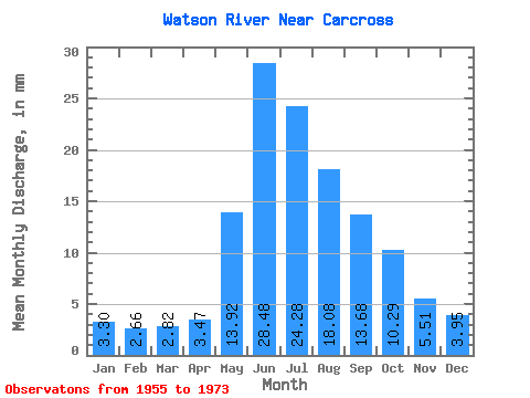
| Statistic | Jan | Feb | Mar | Apr | May | Jun | Jul | Aug | Sep | Oct | Nov | Dec | Annual |
|---|---|---|---|---|---|---|---|---|---|---|---|---|---|
| Mean | 3.30 | 2.68 | 2.82 | 3.47 | 13.92 | 28.48 | 24.28 | 18.08 | 13.68 | 10.29 | 5.51 | 3.95 | 139.57 |
| Standard Deviation | 0.99 | 0.89 | 1.03 | 1.18 | 4.86 | 9.02 | 6.10 | 4.98 | 5.47 | 3.23 | 1.48 | 0.96 | 18.17 |
| Min | 1.25 | 0.84 | 0.70 | 1.56 | 6.52 | 17.11 | 8.52 | 7.87 | 3.13 | 4.49 | 2.46 | 1.66 | 110.44 |
| Max | 4.38 | 3.97 | 4.47 | 5.16 | 20.24 | 43.05 | 33.07 | 26.31 | 25.02 | 16.05 | 7.44 | 5.10 | 158.40 |
| Coefficient of Variation | 0.30 | 0.33 | 0.36 | 0.34 | 0.35 | 0.32 | 0.25 | 0.28 | 0.40 | 0.31 | 0.27 | 0.24 | 0.13 |
 Return to R-Arctic Net Home Page