|
|
| Point ID: 5784 | Downloads | Plots | Site Data | Code: 09AA009 |
|
| Download | |
|---|---|
| Site Descriptor Information | Site Time Series Data |
| Link to all available data | |
|
|
|
| View: | Statistics | All |
| Units: | mm |
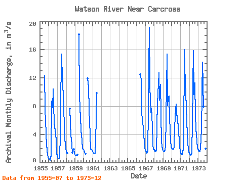
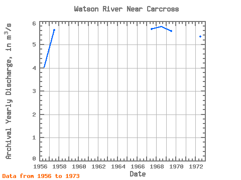
| Year | Jan | Feb | Mar | Apr | May | Jun | Jul | Aug | Sep | Oct | Nov | Dec | Annual | 1955 | 12.30 | 7.60 | 4.14 | 2.44 | 1.09 | 0.71 | 1956 | 0.54 | 0.39 | 0.30 | 1.07 | 8.69 | 7.80 | 10.40 | 5.70 | 5.04 | 4.10 | 2.95 | 1.31 | 4.02 | 1957 | 0.70 | 0.60 | 0.60 | 0.69 | 7.41 | 15.40 | 12.80 | 11.00 | 7.83 | 4.98 | 3.30 | 2.06 | 5.61 | 1958 | 1.50 | 1.35 | 7.66 | 3.66 | 3.38 | 1.39 | 1.92 | 1.24 | 1959 | 1.02 | 0.95 | 0.99 | 1.08 | 18.20 | 9.33 | 6.36 | 4.59 | 3.11 | 1.95 | 1.92 | 1960 | 1.68 | 1.37 | 1.26 | 11.90 | 10.70 | 7.42 | 3.95 | 1.93 | 1.93 | 1.70 | 1961 | 1.52 | 1.36 | 1.36 | 1.36 | 2.98 | 9.86 | 1966 | 12.50 | 11.80 | 6.97 | 5.41 | 5.09 | 2.88 | 2.04 | 1967 | 1.68 | 1.47 | 1.35 | 1.63 | 7.54 | 19.10 | 10.80 | 7.10 | 7.68 | 5.24 | 2.51 | 1.83 | 5.66 | 1968 | 1.80 | 1.58 | 1.53 | 1.91 | 8.40 | 9.68 | 12.70 | 8.86 | 11.10 | 6.89 | 2.91 | 1.90 | 5.77 | 1969 | 1.68 | 1.61 | 1.54 | 2.24 | 6.31 | 15.40 | 8.04 | 9.15 | 9.45 | 6.21 | 3.06 | 2.19 | 5.57 | 1970 | 1.88 | 1.87 | 1.92 | 2.29 | 5.11 | 7.59 | 8.31 | 6.15 | 5.90 | 4.41 | 2.94 | 1.61 | 4.17 | 1971 | 1.36 | 1.13 | 1.14 | 1.34 | 2.80 | 16.00 | 11.30 | 9.78 | 5.84 | 4.00 | 1.83 | 1.50 | 4.83 | 1972 | 1.31 | 1.12 | 1.02 | 1.30 | 5.81 | 15.90 | 9.63 | 11.30 | 6.66 | 4.82 | 3.03 | 2.15 | 5.34 | 1973 | 1.75 | 1.63 | 1.52 | 2.04 | 4.73 | 9.92 | 14.20 | 7.93 | 5.97 | 4.24 | 1.94 | 1.60 | 4.79 |
|---|
 Return to R-Arctic Net Home Page