|
|
|||||||||||||||||
| Point ID: 5123 | Downloads | Plots | Site Data | Other Close Sites | Code: 03DD003 |
|
|
|||||||||||||||||
| Download | |
|---|---|
| Site Descriptor Information | Site Time Series Data |
| Link to all available data | |
| View: | Time Series | All |
| Units: | mm |
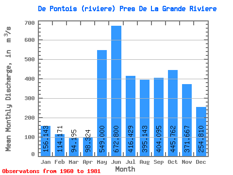
| Statistic | Jan | Feb | Mar | Apr | May | Jun | Jul | Aug | Sep | Oct | Nov | Dec | Annual |
|---|---|---|---|---|---|---|---|---|---|---|---|---|---|
| Mean | 156.14 | 114.17 | 94.19 | 98.32 | 549.00 | 672.80 | 416.43 | 395.14 | 404.10 | 445.76 | 371.67 | 254.81 | 330.75 |
| Standard Deviation | 29.77 | 19.70 | 17.36 | 23.50 | 193.13 | 160.69 | 108.51 | 139.61 | 120.66 | 131.25 | 97.87 | 62.60 | 50.20 |
| Min | 107.00 | 82.10 | 69.40 | 65.20 | 292.00 | 354.00 | 252.00 | 212.00 | 199.00 | 248.00 | 227.00 | 160.00 | 237.97 |
| Max | 239.00 | 173.00 | 141.00 | 156.00 | 1030.00 | 968.00 | 682.00 | 656.00 | 621.00 | 668.00 | 653.00 | 393.00 | 440.96 |
| Coefficient of Variation | 0.19 | 0.17 | 0.18 | 0.24 | 0.35 | 0.24 | 0.26 | 0.35 | 0.30 | 0.29 | 0.26 | 0.25 | 0.15 |
| Other Close Sites | ||||||
|---|---|---|---|---|---|---|
| PointID | Latitude | Longitude | Drainage Area | Source | Name | |
| 5117 | "GRANDE RIVIERE (LA) EN AMONT DE LA RIVIERE DE PONTOIS" | 53.62 | -1061683 | Hydat | ||
 Return to R-Arctic Net Home Page