|
|
|||||||||||||||||
| Point ID: 5123 | Downloads | Plots | Site Data | Other Close Sites | Code: 03DD003 |
|
|
|||||||||||||||||
| Download | |
|---|---|
| Site Descriptor Information | Site Time Series Data |
| Link to all available data | |
| View: | Time Series | All |
| Units: | m3/s |
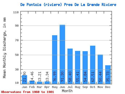
| Statistic | Jan | Feb | Mar | Apr | May | Jun | Jul | Aug | Sep | Oct | Nov | Dec | Annual |
|---|---|---|---|---|---|---|---|---|---|---|---|---|---|
| Mean | 21.89 | 14.59 | 13.21 | 13.34 | 76.97 | 91.30 | 58.39 | 55.40 | 54.84 | 62.50 | 50.44 | 35.73 | 546.51 |
| Standard Deviation | 4.17 | 2.52 | 2.44 | 3.19 | 27.08 | 21.81 | 15.21 | 19.57 | 16.37 | 18.40 | 13.28 | 8.78 | 82.95 |
| Min | 15.00 | 10.49 | 9.73 | 8.85 | 40.94 | 48.04 | 35.33 | 29.72 | 27.01 | 34.77 | 30.80 | 22.43 | 393.21 |
| Max | 33.51 | 22.10 | 19.77 | 21.17 | 144.42 | 131.36 | 95.62 | 91.98 | 84.27 | 93.66 | 88.62 | 55.10 | 728.62 |
| Coefficient of Variation | 0.19 | 0.17 | 0.18 | 0.24 | 0.35 | 0.24 | 0.26 | 0.35 | 0.30 | 0.29 | 0.26 | 0.25 | 0.15 |
| Other Close Sites | ||||||
|---|---|---|---|---|---|---|
| PointID | Latitude | Longitude | Drainage Area | Source | Name | |
| 5117 | "GRANDE RIVIERE (LA) EN AMONT DE LA RIVIERE DE PONTOIS" | 53.62 | -1061683 | Hydat | ||
 Return to R-Arctic Net Home Page