|
|
|||||||||||||||||
| Point ID: 5117 | Downloads | Plots | Site Data | Other Close Sites | Code: 03DC002 |
|
|
|||||||||||||||||
| Download | |
|---|---|
| Site Descriptor Information | Site Time Series Data |
| Link to all available data | |
| View: | Time Series | All |
| Units: | mm |
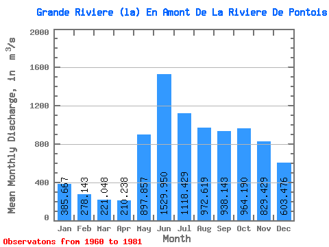
| Statistic | Jan | Feb | Mar | Apr | May | Jun | Jul | Aug | Sep | Oct | Nov | Dec | Annual |
|---|---|---|---|---|---|---|---|---|---|---|---|---|---|
| Mean | 385.67 | 278.14 | 221.05 | 210.24 | 897.86 | 1529.95 | 1118.43 | 972.62 | 938.14 | 964.19 | 829.43 | 603.48 | 742.79 |
| Standard Deviation | 104.82 | 61.61 | 40.93 | 37.64 | 370.95 | 362.68 | 307.56 | 341.21 | 300.44 | 240.58 | 214.73 | 169.37 | 133.61 |
| Min | 263.00 | 203.00 | 155.00 | 141.00 | 423.00 | 750.00 | 760.00 | 525.00 | 518.00 | 510.00 | 432.00 | 360.00 | 537.75 |
| Max | 705.00 | 453.00 | 331.00 | 282.00 | 1870.00 | 2100.00 | 2040.00 | 1700.00 | 1550.00 | 1350.00 | 1310.00 | 1060.00 | 978.17 |
| Coefficient of Variation | 0.27 | 0.22 | 0.18 | 0.18 | 0.41 | 0.24 | 0.28 | 0.35 | 0.32 | 0.25 | 0.26 | 0.28 | 0.18 |
| Other Close Sites | ||||||
|---|---|---|---|---|---|---|
| PointID | Latitude | Longitude | Drainage Area | Source | Name | |
| 5123 | "DE PONTOIS (RIVIERE) PRES DE LA GRANDE RIVIERE" | 53.62 | -1049635 | Hydat | ||
 Return to R-Arctic Net Home Page