|
|
|||||||||||||||||
| Point ID: 3666 | Downloads | Plots | Site Data | Code: 10MC007 |
|
|
|||||||||||||||||
| Download | |
|---|---|
| Site Descriptor Information | Site Time Series Data |
| Link to all available data | |
| View: | Time Series | All |
| Units: | mm |
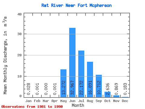
| Statistic | Jan | Feb | Mar | Apr | May | Jun | Jul | Aug | Sep | Oct | Nov | Dec | Annual |
|---|---|---|---|---|---|---|---|---|---|---|---|---|---|
| Mean | 0.03 | 0.00 | 0.00 | 0.00 | 13.27 | 32.97 | 22.17 | 16.89 | 10.71 | 2.64 | 0.87 | 0.18 | 8.41 |
| Standard Deviation | 0.04 | 0.00 | 0.00 | 0.00 | 9.68 | 6.32 | 14.62 | 7.53 | 3.73 | 0.86 | 0.36 | 0.15 | 2.00 |
| Min | 0.00 | 0.00 | 0.00 | 0.00 | 2.65 | 26.60 | 8.55 | 7.87 | 5.02 | 0.77 | 0.12 | 0.00 | 5.92 |
| Max | 0.10 | 0.01 | 0.00 | 0.01 | 30.30 | 48.80 | 54.40 | 28.10 | 17.80 | 4.01 | 1.32 | 0.39 | 12.89 |
| Coefficient of Variation | 1.27 | 2.14 | 3.16 | 0.73 | 0.19 | 0.66 | 0.45 | 0.35 | 0.33 | 0.41 | 0.84 | 0.24 |
 Return to R-Arctic Net Home Page