|
|
|||||||||||||||||
| Point ID: 3666 | Downloads | Plots | Site Data | Code: 10MC007 |
|
|
|||||||||||||||||
| Download | |
|---|---|
| Site Descriptor Information | Site Time Series Data |
| Link to all available data | |
| View: | Time Series | All |
| Units: | m3/s |
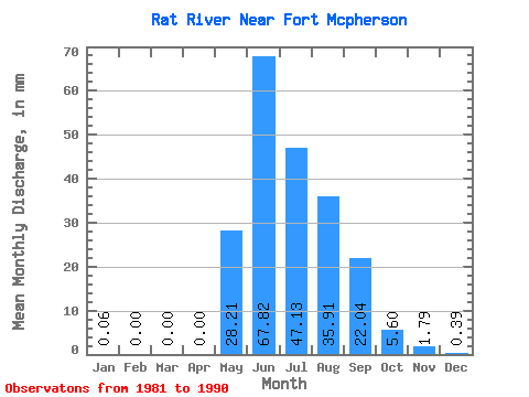
| Statistic | Jan | Feb | Mar | Apr | May | Jun | Jul | Aug | Sep | Oct | Nov | Dec | Annual |
|---|---|---|---|---|---|---|---|---|---|---|---|---|---|
| Mean | 0.06 | 0.00 | 0.00 | 0.00 | 28.21 | 67.82 | 47.12 | 35.90 | 22.04 | 5.60 | 1.79 | 0.39 | 210.68 |
| Standard Deviation | 0.07 | 0.01 | 0.00 | 0.01 | 20.57 | 13.01 | 31.07 | 16.01 | 7.67 | 1.83 | 0.74 | 0.33 | 50.03 |
| Min | 0.00 | 0.00 | 0.00 | 0.00 | 5.63 | 54.72 | 18.17 | 16.73 | 10.33 | 1.63 | 0.24 | 0.00 | 148.19 |
| Max | 0.21 | 0.01 | 0.00 | 0.03 | 64.40 | 100.39 | 115.62 | 59.72 | 36.62 | 8.52 | 2.71 | 0.83 | 322.91 |
| Coefficient of Variation | 1.27 | 2.14 | 3.16 | 0.73 | 0.19 | 0.66 | 0.45 | 0.35 | 0.33 | 0.41 | 0.84 | 0.24 |
 Return to R-Arctic Net Home Page