|
|
| Point ID: 3666 | Downloads | Plots | Site Data | Code: 10MC007 |
|
| Download | |
|---|---|
| Site Descriptor Information | Site Time Series Data |
| Link to all available data | |
|
|
|
| View: | Statistics | All |
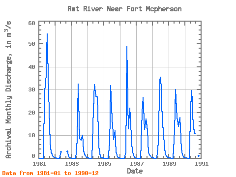
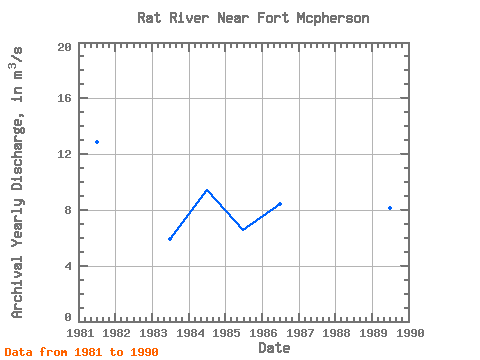
| Units: | mm |
| Year | Jan | Feb | Mar | Apr | May | Jun | Jul | Aug | Sep | Oct | Nov | Dec | Annual | 1981 | 0.00 | 0.00 | 0.00 | 0.00 | 30.30 | 31.20 | 54.40 | 28.10 | 6.67 | 2.61 | 1.03 | 0.39 | 12.89 | 1982 | 0.05 | 0.00 | 0.00 | 0.00 | 2.71 | 2.92 | 0.47 | 0.02 | 1983 | 0.00 | 0.00 | 0.00 | 0.00 | 7.63 | 32.40 | 8.55 | 7.87 | 10.00 | 3.15 | 1.13 | 0.27 | 5.92 | 1984 | 0.02 | 0.00 | 0.00 | 0.00 | 21.20 | 32.10 | 26.90 | 26.80 | 5.02 | 0.77 | 0.12 | 0.00 | 9.41 | 1985 | 0.00 | 0.00 | 0.00 | 0.00 | 6.29 | 31.70 | 17.20 | 8.15 | 11.90 | 2.62 | 0.63 | 0.04 | 6.54 | 1986 | 0.00 | 0.00 | 0.00 | 0.00 | 2.65 | 48.80 | 12.70 | 21.90 | 10.50 | 3.14 | 0.99 | 0.00 | 8.39 | 1987 | 0.00 | 0.00 | 0.00 | 0.00 | 19.80 | 26.60 | 12.60 | 17.10 | 12.10 | 2.20 | 1.13 | 0.37 | 7.66 | 1988 | 0.07 | 0.00 | 0.00 | 0.01 | 6.74 | 34.40 | 35.30 | 17.50 | 9.22 | 2.01 | 0.97 | 0.31 | 8.88 | 1989 | 0.10 | 0.01 | 0.00 | 0.00 | 12.20 | 30.00 | 17.80 | 13.80 | 17.80 | 4.01 | 1.32 | 0.21 | 8.10 | 1990 | 0.04 | 0.01 | 0.00 | 0.00 | 23.20 | 29.50 | 14.10 | 10.80 | 13.20 | 2.93 | 0.91 | 0.22 | 7.91 |
|---|
 Return to R-Arctic Net Home Page