|
|
|||||||||||||||||
| Point ID: 2954 | Downloads | Plots | Site Data | Code: 05OA001 |
|
|
|||||||||||||||||
| Download | |
|---|---|
| Site Descriptor Information | Site Time Series Data |
| Link to all available data | |
| View: | Time Series | All |
| Units: | mm |
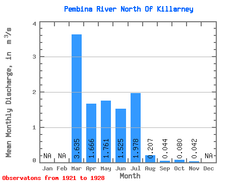
| Statistic | Jan | Feb | Mar | Apr | May | Jun | Jul | Aug | Sep | Oct | Nov | Dec | Annual |
|---|---|---|---|---|---|---|---|---|---|---|---|---|---|
| Mean | 3.63 | 1.67 | 1.76 | 1.52 | 1.98 | 0.21 | 0.04 | 0.08 | 0.04 | ||||
| Standard Deviation | 2.34 | 1.50 | 3.17 | 1.01 | 2.16 | 0.21 | 0.03 | 0.00 | |||||
| Min | 1.98 | 0.46 | 0.07 | 0.05 | 0.01 | 0.00 | 0.01 | 0.08 | 0.04 | ||||
| Max | 5.29 | 3.34 | 6.52 | 2.34 | 4.29 | 0.42 | 0.07 | 0.08 | 0.04 | ||||
| Coefficient of Variation | 0.64 | 0.90 | 1.80 | 0.66 | 1.09 | 1.02 | 0.76 | 0.04 |
 Return to R-Arctic Net Home Page