|
|
|||||||||||||||||
| Point ID: 2954 | Downloads | Plots | Site Data | Code: 05OA001 |
|
|
|||||||||||||||||
| Download | |
|---|---|
| Site Descriptor Information | Site Time Series Data |
| Link to all available data | |
| View: | Time Series | All |
| Units: | m3/s |
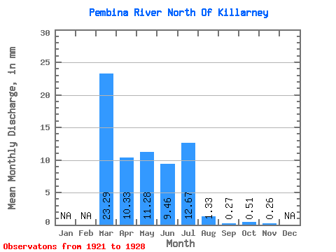
| Statistic | Jan | Feb | Mar | Apr | May | Jun | Jul | Aug | Sep | Oct | Nov | Dec | Annual |
|---|---|---|---|---|---|---|---|---|---|---|---|---|---|
| Mean | 23.29 | 10.33 | 11.28 | 9.46 | 12.68 | 1.33 | 0.27 | 0.51 | 0.26 | ||||
| Standard Deviation | 14.99 | 9.28 | 20.33 | 6.26 | 13.85 | 1.36 | 0.21 | 0.02 | |||||
| Min | 12.69 | 2.83 | 0.46 | 0.32 | 0.03 | 0.00 | 0.04 | 0.49 | 0.26 | ||||
| Max | 33.89 | 20.71 | 41.77 | 14.51 | 27.48 | 2.71 | 0.43 | 0.53 | 0.26 | ||||
| Coefficient of Variation | 0.64 | 0.90 | 1.80 | 0.66 | 1.09 | 1.02 | 0.76 | 0.04 |
 Return to R-Arctic Net Home Page