|
|
| Point ID: 2954 | Downloads | Plots | Site Data | Code: 05OA001 |
|
| Download | |
|---|---|
| Site Descriptor Information | Site Time Series Data |
| Link to all available data | |
|
|
|
| View: | Statistics | All |
| Units: | m3/s |
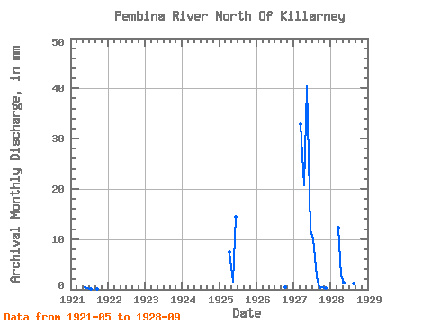
| Year | Jan | Feb | Mar | Apr | May | Jun | Jul | Aug | Sep | Oct | Nov | Dec | Annual | 1921 | 0.46 | 0.32 | 0.03 | 0.00 | 0.04 | 1925 | 7.44 | 1.57 | 14.51 | 1926 | 0.49 | 1927 | 33.89 | 20.71 | 41.77 | 11.72 | 10.51 | 2.71 | 0.35 | 0.53 | 0.26 | 1928 | 12.69 | 2.83 | 1.32 | 11.29 | 27.48 | 1.27 | 0.43 |
|---|
 Return to R-Arctic Net Home Page