|
|
| Point ID: 2954 | Downloads | Plots | Site Data | Code: 05OA001 |
|
| Download | |
|---|---|
| Site Descriptor Information | Site Time Series Data |
| Link to all available data | |
|
|
|
| View: | Statistics | All |
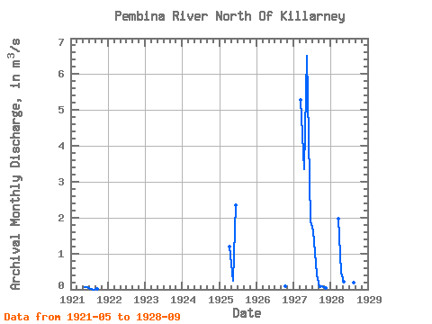
| Units: | mm |
| Year | Jan | Feb | Mar | Apr | May | Jun | Jul | Aug | Sep | Oct | Nov | Dec | Annual | 1921 | 0.07 | 0.05 | 0.01 | 0.00 | 0.01 | 1925 | 1.20 | 0.24 | 2.34 | 1926 | 0.08 | 1927 | 5.29 | 3.34 | 6.52 | 1.89 | 1.64 | 0.42 | 0.06 | 0.08 | 0.04 | 1928 | 1.98 | 0.46 | 0.21 | 1.82 | 4.29 | 0.20 | 0.07 |
|---|
 Return to R-Arctic Net Home Page