|
|
|||||||||||||||||
| Point ID: 9519 | Downloads | Plots | Site Data | Code: 15291200 |
|
|
|||||||||||||||||
| Download | |
|---|---|
| Site Descriptor Information | Site Time Series Data |
| Link to all available data | |
| View: | Time Series | All |
| Units: | m3/s |
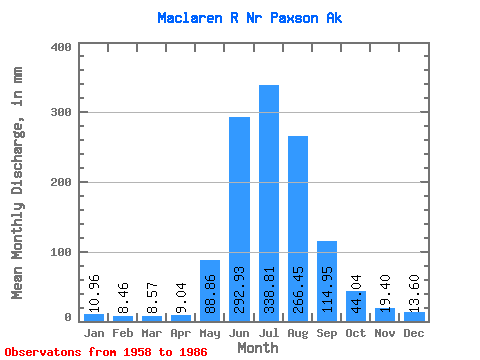
| Statistic | Jan | Feb | Mar | Apr | May | Jun | Jul | Aug | Sep | Oct | Nov | Dec | Annual |
|---|---|---|---|---|---|---|---|---|---|---|---|---|---|
| Mean | 10.96 | 8.54 | 8.57 | 9.04 | 88.84 | 292.93 | 338.76 | 266.41 | 114.95 | 44.03 | 19.41 | 13.60 | 1201.56 |
| Standard Deviation | 3.57 | 2.44 | 2.46 | 2.54 | 46.31 | 64.55 | 57.51 | 71.13 | 44.36 | 12.68 | 6.35 | 5.02 | 178.86 |
| Min | 4.60 | 4.00 | 4.29 | 5.06 | 21.71 | 177.18 | 255.21 | 101.89 | 47.55 | 26.07 | 9.62 | 5.15 | 852.82 |
| Max | 16.93 | 13.30 | 12.68 | 14.68 | 222.80 | 434.93 | 497.34 | 430.99 | 246.88 | 76.74 | 37.48 | 25.70 | 1565.76 |
| Coefficient of Variation | 0.33 | 0.28 | 0.29 | 0.28 | 0.52 | 0.22 | 0.17 | 0.27 | 0.39 | 0.29 | 0.33 | 0.37 | 0.15 |
 Return to R-Arctic Net Home Page