|
|
|||||||||||||||||
| Point ID: 9519 | Downloads | Plots | Site Data | Code: 15291200 |
|
|
|||||||||||||||||
| Download | |
|---|---|
| Site Descriptor Information | Site Time Series Data |
| Link to all available data | |
| View: | Time Series | All |
| Units: | mm |
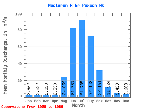
| Statistic | Jan | Feb | Mar | Apr | May | Jun | Jul | Aug | Sep | Oct | Nov | Dec | Annual |
|---|---|---|---|---|---|---|---|---|---|---|---|---|---|
| Mean | 2.97 | 2.54 | 2.32 | 2.53 | 24.06 | 81.96 | 91.73 | 72.14 | 32.16 | 11.92 | 5.43 | 3.68 | 27.61 |
| Standard Deviation | 0.97 | 0.72 | 0.67 | 0.71 | 12.54 | 18.06 | 15.57 | 19.26 | 12.41 | 3.43 | 1.78 | 1.36 | 4.11 |
| Min | 1.25 | 1.19 | 1.16 | 1.42 | 5.88 | 49.57 | 69.11 | 27.59 | 13.30 | 7.06 | 2.69 | 1.40 | 19.60 |
| Max | 4.59 | 3.95 | 3.44 | 4.11 | 60.33 | 121.69 | 134.68 | 116.71 | 69.07 | 20.78 | 10.49 | 6.96 | 35.98 |
| Coefficient of Variation | 0.33 | 0.28 | 0.29 | 0.28 | 0.52 | 0.22 | 0.17 | 0.27 | 0.39 | 0.29 | 0.33 | 0.37 | 0.15 |
 Return to R-Arctic Net Home Page