|
|
|||||||||||||||||
| Point ID: 9519 | Downloads | Plots | Site Data | Code: 15291200 |
|
|
|||||||||||||||||
| Download | |
|---|---|
| Site Descriptor Information | Site Time Series Data |
| Link to all available data | |
|
|
| View: | Statistics | Time Series |
| Units: | m3/s |
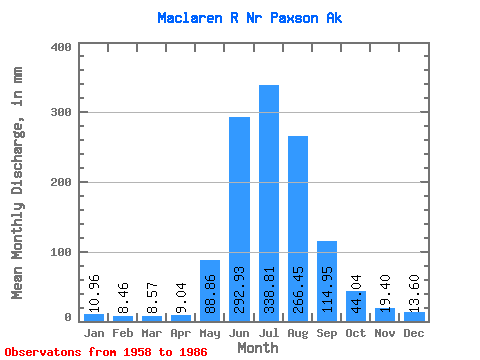
| Statistic | Jan | Feb | Mar | Apr | May | Jun | Jul | Aug | Sep | Oct | Nov | Dec | Annual |
|---|---|---|---|---|---|---|---|---|---|---|---|---|---|
| Mean | 10.96 | 8.54 | 8.57 | 9.04 | 88.84 | 292.93 | 338.76 | 266.41 | 114.95 | 44.03 | 19.41 | 13.60 | 1201.56 |
| Standard Deviation | 3.57 | 2.44 | 2.46 | 2.54 | 46.31 | 64.55 | 57.51 | 71.13 | 44.36 | 12.68 | 6.35 | 5.02 | 178.86 |
| Min | 4.60 | 4.00 | 4.29 | 5.06 | 21.71 | 177.18 | 255.21 | 101.89 | 47.55 | 26.07 | 9.62 | 5.15 | 852.82 |
| Max | 16.93 | 13.30 | 12.68 | 14.68 | 222.80 | 434.93 | 497.34 | 430.99 | 246.88 | 76.74 | 37.48 | 25.70 | 1565.76 |
| Coefficient of Variation | 0.33 | 0.28 | 0.29 | 0.28 | 0.52 | 0.22 | 0.17 | 0.27 | 0.39 | 0.29 | 0.33 | 0.37 | 0.15 |
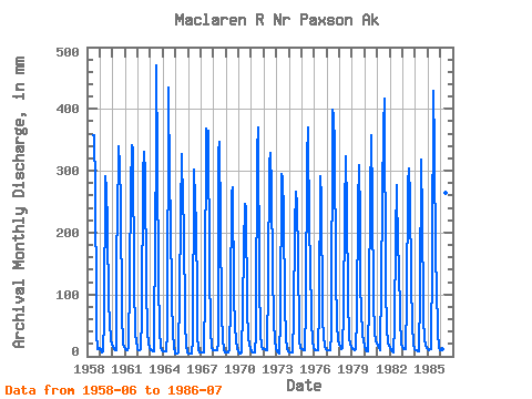
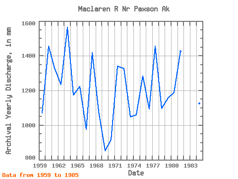
| Year | Jan | Feb | Mar | Apr | May | Jun | Jul | Aug | Sep | Oct | Nov | Dec | Annual | 1958 | 357.51 | 368.58 | 282.23 | 79.33 | 39.50 | 11.64 | 12.89 | 1959 | 13.53 | 9.09 | 6.53 | 7.84 | 61.42 | 291.35 | 280.24 | 217.84 | 86.62 | 57.43 | 25.30 | 19.87 | 1072.02 | 1960 | 15.65 | 10.51 | 9.86 | 9.26 | 182.18 | 214.94 | 351.21 | 318.70 | 246.88 | 71.81 | 19.74 | 15.62 | 1457.09 | 1961 | 11.54 | 8.95 | 10.04 | 14.68 | 129.36 | 271.07 | 352.29 | 345.01 | 118.22 | 39.83 | 21.26 | 17.78 | 1330.70 | 1962 | 12.55 | 9.53 | 9.62 | 12.14 | 66.11 | 295.10 | 341.36 | 306.05 | 114.04 | 40.04 | 21.26 | 13.59 | 1234.47 | 1963 | 10.46 | 8.67 | 8.36 | 8.40 | 222.80 | 314.76 | 486.11 | 327.90 | 122.81 | 43.53 | 14.17 | 10.25 | 1565.76 | 1964 | 8.89 | 8.38 | 7.42 | 7.29 | 40.38 | 434.93 | 288.98 | 232.54 | 88.14 | 39.67 | 14.85 | 5.15 | 1174.10 | 1965 | 4.60 | 4.00 | 4.29 | 6.28 | 102.85 | 229.58 | 337.01 | 251.87 | 212.32 | 54.57 | 18.22 | 5.75 | 1224.85 | 1966 | 4.71 | 4.29 | 4.50 | 5.06 | 27.66 | 302.58 | 261.96 | 219.05 | 96.54 | 38.57 | 9.62 | 7.32 | 978.14 | 1967 | 6.80 | 5.72 | 5.75 | 5.40 | 106.93 | 367.83 | 340.32 | 376.98 | 143.32 | 43.65 | 13.12 | 10.46 | 1418.51 | 1968 | 10.19 | 9.05 | 9.93 | 9.62 | 21.71 | 328.46 | 358.40 | 222.66 | 68.83 | 27.73 | 12.23 | 7.17 | 1081.03 | 1969 | 6.09 | 5.24 | 6.02 | 9.65 | 88.78 | 264.49 | 281.49 | 101.89 | 47.55 | 26.07 | 11.88 | 7.66 | 852.82 | 1970 | 6.21 | 4.80 | 5.51 | 7.00 | 78.02 | 177.18 | 255.21 | 247.52 | 78.19 | 31.47 | 19.43 | 13.70 | 917.32 | 1971 | 8.72 | 5.75 | 5.75 | 6.68 | 38.17 | 345.50 | 368.89 | 382.65 | 117.93 | 39.25 | 15.82 | 12.88 | 1340.21 | 1972 | 12.01 | 10.19 | 10.19 | 9.97 | 127.37 | 310.58 | 340.42 | 279.84 | 138.29 | 57.55 | 24.56 | 14.23 | 1327.98 | 1973 | 9.14 | 6.21 | 5.58 | 5.18 | 60.24 | 294.12 | 298.66 | 237.47 | 83.07 | 32.15 | 12.47 | 8.63 | 1047.52 | 1974 | 7.17 | 5.89 | 5.92 | 5.73 | 67.89 | 209.44 | 275.45 | 255.06 | 156.21 | 40.28 | 23.45 | 14.67 | 1061.46 | 1975 | 12.04 | 10.48 | 10.46 | 10.39 | 80.31 | 321.68 | 381.60 | 207.21 | 159.27 | 57.84 | 23.78 | 14.50 | 1284.26 | 1976 | 11.06 | 8.97 | 9.41 | 10.63 | 81.63 | 290.51 | 293.87 | 272.25 | 60.77 | 31.57 | 16.97 | 12.41 | 1093.54 | 1977 | 10.17 | 8.77 | 9.41 | 9.40 | 38.32 | 398.97 | 400.90 | 354.92 | 131.30 | 53.57 | 26.85 | 19.50 | 1455.18 | 1978 | 16.93 | 13.30 | 12.68 | 13.56 | 74.11 | 234.50 | 334.24 | 246.38 | 93.52 | 32.11 | 19.43 | 14.88 | 1098.87 | 1979 | 12.78 | 10.48 | 10.46 | 11.20 | 66.28 | 245.94 | 319.54 | 232.41 | 115.04 | 76.74 | 37.48 | 25.70 | 1157.54 | 1980 | 16.76 | 10.05 | 8.55 | 8.15 | 94.18 | 254.68 | 369.50 | 258.42 | 92.82 | 38.52 | 26.04 | 21.12 | 1190.70 | 1981 | 16.66 | 12.38 | 11.60 | 9.58 | 121.70 | 253.40 | 383.36 | 430.99 | 112.65 | 46.35 | 23.24 | 17.78 | 1428.08 | 1982 | 14.40 | 8.85 | 8.06 | 6.95 | 51.88 | 196.41 | 285.98 | 175.30 | 157.64 | 54.00 | 29.08 | 20.81 | 1004.84 | 1983 | 15.45 | 11.71 | 12.18 | 12.45 | 89.15 | 278.46 | 313.84 | 265.20 | 121.08 | 50.33 | 20.21 | 12.62 | 1196.31 | 1984 | 9.97 | 8.58 | 8.69 | 8.88 | 101.14 | 318.10 | 307.60 | 250.93 | 60.49 | 29.04 | 16.60 | 13.39 | 1127.07 | 1985 | 11.84 | 9.70 | 11.17 | 11.17 | 163.29 | 428.46 | 349.63 | 160.13 | 115.73 | 39.73 | 14.68 | 10.53 | 1321.78 | 1986 | 10.46 | 9.53 | 11.97 | 10.66 | 103.72 | 264.50 | 497.34 |
|---|
 Return to R-Arctic Net Home Page