|
|
|||||||||||||||||
| Point ID: 9505 | Downloads | Plots | Site Data | Code: 15277100 |
|
|
|||||||||||||||||
| Download | |
|---|---|
| Site Descriptor Information | Site Time Series Data |
| Link to all available data | |
| View: | Time Series | All |
| Units: | m3/s |
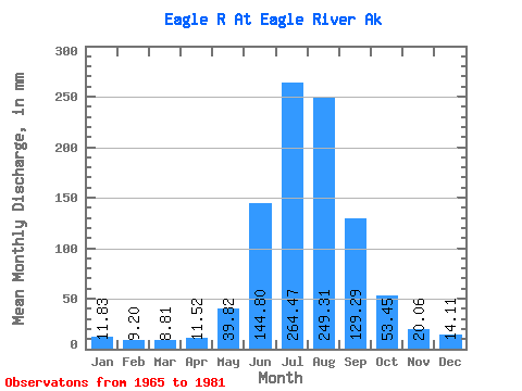
| Statistic | Jan | Feb | Mar | Apr | May | Jun | Jul | Aug | Sep | Oct | Nov | Dec | Annual |
|---|---|---|---|---|---|---|---|---|---|---|---|---|---|
| Mean | 11.82 | 9.28 | 8.81 | 11.52 | 39.82 | 144.80 | 264.44 | 249.28 | 129.28 | 53.45 | 20.06 | 14.10 | 943.17 |
| Standard Deviation | 5.74 | 5.33 | 2.77 | 3.74 | 14.78 | 37.26 | 45.91 | 65.33 | 48.83 | 23.38 | 5.77 | 3.96 | 186.94 |
| Min | 5.90 | 3.62 | 5.54 | 5.26 | 12.52 | 97.76 | 196.73 | 133.26 | 63.44 | 23.66 | 12.64 | 8.16 | 660.99 |
| Max | 28.53 | 25.80 | 14.14 | 19.09 | 72.76 | 222.36 | 347.82 | 369.56 | 235.06 | 107.86 | 32.26 | 20.95 | 1263.90 |
| Coefficient of Variation | 0.49 | 0.57 | 0.32 | 0.33 | 0.37 | 0.26 | 0.17 | 0.26 | 0.38 | 0.44 | 0.29 | 0.28 | 0.20 |
 Return to R-Arctic Net Home Page