|
|
|||||||||||||||||
| Point ID: 9505 | Downloads | Plots | Site Data | Code: 15277100 |
|
|
|||||||||||||||||
| Download | |
|---|---|
| Site Descriptor Information | Site Time Series Data |
| Link to all available data | |
| View: | Time Series | All |
| Units: | mm |
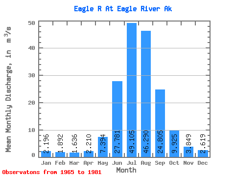
| Statistic | Jan | Feb | Mar | Apr | May | Jun | Jul | Aug | Sep | Oct | Nov | Dec | Annual |
|---|---|---|---|---|---|---|---|---|---|---|---|---|---|
| Mean | 2.20 | 1.89 | 1.64 | 2.21 | 7.39 | 27.78 | 49.10 | 46.29 | 24.80 | 9.93 | 3.85 | 2.62 | 14.86 |
| Standard Deviation | 1.07 | 1.09 | 0.52 | 0.72 | 2.75 | 7.15 | 8.52 | 12.13 | 9.37 | 4.34 | 1.11 | 0.73 | 2.95 |
| Min | 1.09 | 0.74 | 1.03 | 1.01 | 2.33 | 18.76 | 36.53 | 24.75 | 12.17 | 4.39 | 2.43 | 1.52 | 10.41 |
| Max | 5.30 | 5.26 | 2.63 | 3.66 | 13.51 | 42.66 | 64.59 | 68.63 | 45.10 | 20.03 | 6.19 | 3.89 | 19.92 |
| Coefficient of Variation | 0.49 | 0.57 | 0.32 | 0.33 | 0.37 | 0.26 | 0.17 | 0.26 | 0.38 | 0.44 | 0.29 | 0.28 | 0.20 |
 Return to R-Arctic Net Home Page