|
|
|||||||||||||||||
| Point ID: 9505 | Downloads | Plots | Site Data | Code: 15277100 |
|
|
|||||||||||||||||
| Download | |
|---|---|
| Site Descriptor Information | Site Time Series Data |
| Link to all available data | |
|
|
| View: | Statistics | Time Series |
| Units: | m3/s |
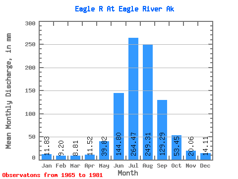
| Statistic | Jan | Feb | Mar | Apr | May | Jun | Jul | Aug | Sep | Oct | Nov | Dec | Annual |
|---|---|---|---|---|---|---|---|---|---|---|---|---|---|
| Mean | 11.82 | 9.28 | 8.81 | 11.52 | 39.82 | 144.80 | 264.44 | 249.28 | 129.28 | 53.45 | 20.06 | 14.10 | 943.17 |
| Standard Deviation | 5.74 | 5.33 | 2.77 | 3.74 | 14.78 | 37.26 | 45.91 | 65.33 | 48.83 | 23.38 | 5.77 | 3.96 | 186.94 |
| Min | 5.90 | 3.62 | 5.54 | 5.26 | 12.52 | 97.76 | 196.73 | 133.26 | 63.44 | 23.66 | 12.64 | 8.16 | 660.99 |
| Max | 28.53 | 25.80 | 14.14 | 19.09 | 72.76 | 222.36 | 347.82 | 369.56 | 235.06 | 107.86 | 32.26 | 20.95 | 1263.90 |
| Coefficient of Variation | 0.49 | 0.57 | 0.32 | 0.33 | 0.37 | 0.26 | 0.17 | 0.26 | 0.38 | 0.44 | 0.29 | 0.28 | 0.20 |
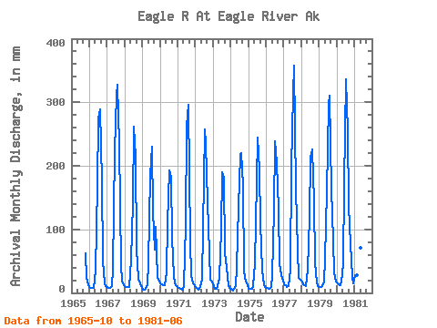
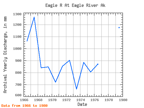
| Year | Jan | Feb | Mar | Apr | May | Jun | Jul | Aug | Sep | Oct | Nov | Dec | Annual | 1965 | 64.78 | 23.91 | 12.59 | 1966 | 7.85 | 6.95 | 7.62 | 7.53 | 35.81 | 169.73 | 283.33 | 298.58 | 173.67 | 52.22 | 15.23 | 11.80 | 1063.73 | 1967 | 10.21 | 7.12 | 8.02 | 11.07 | 38.92 | 222.36 | 322.64 | 338.62 | 235.06 | 43.94 | 19.63 | 12.49 | 1263.90 | 1968 | 10.92 | 8.83 | 9.25 | 9.30 | 54.34 | 141.78 | 270.74 | 221.04 | 70.21 | 23.66 | 15.72 | 10.68 | 839.86 | 1969 | 5.90 | 4.43 | 6.34 | 11.59 | 49.17 | 184.74 | 238.47 | 133.26 | 67.45 | 107.86 | 25.63 | 18.20 | 847.61 | 1970 | 15.15 | 12.51 | 12.94 | 11.57 | 33.24 | 109.12 | 198.62 | 189.22 | 86.76 | 27.54 | 15.18 | 11.41 | 718.75 | 1971 | 8.73 | 7.22 | 6.12 | 5.26 | 12.52 | 106.94 | 270.21 | 305.22 | 81.52 | 29.18 | 14.76 | 13.75 | 853.49 | 1972 | 9.94 | 5.41 | 5.54 | 8.71 | 22.06 | 101.64 | 266.35 | 242.25 | 143.16 | 63.70 | 21.11 | 18.69 | 901.75 | 1973 | 11.21 | 6.72 | 6.76 | 10.53 | 24.41 | 97.76 | 196.73 | 187.18 | 63.44 | 40.73 | 12.64 | 8.16 | 660.99 | 1974 | 5.94 | 3.62 | 6.16 | 11.36 | 41.51 | 135.97 | 224.40 | 227.02 | 168.42 | 35.28 | 18.18 | 12.37 | 885.52 | 1975 | 7.34 | 6.18 | 6.78 | 11.37 | 47.77 | 110.12 | 251.85 | 199.38 | 111.59 | 36.18 | 13.43 | 9.88 | 805.93 | 1976 | 8.57 | 7.39 | 7.00 | 9.40 | 26.99 | 131.18 | 246.24 | 211.31 | 132.87 | 46.76 | 28.09 | 19.77 | 870.41 | 1977 | 14.41 | 10.97 | 9.52 | 11.46 | 37.93 | 196.79 | 323.33 | 369.56 | 162.41 | 70.16 | 23.33 | 20.95 | 1242.30 | 1978 | 17.95 | 13.45 | 12.08 | 10.58 | 37.48 | 120.37 | 220.65 | 232.94 | 143.38 | 49.39 | 17.09 | 10.95 | 881.20 | 1979 | 9.91 | 8.46 | 10.53 | 17.24 | 55.77 | 159.65 | 305.17 | 320.67 | 162.09 | 84.77 | 32.26 | 18.69 | 1176.89 | 1980 | 16.63 | 13.46 | 12.13 | 18.25 | 46.39 | 169.22 | 347.82 | 262.88 | 137.25 | 78.97 | 24.78 | 15.25 | 1135.21 | 1981 | 28.53 | 25.80 | 14.14 | 19.09 | 72.76 | 159.41 |
|---|
 Return to R-Arctic Net Home Page