|
|
|||||||||||||||||
| Point ID: 9502 | Downloads | Plots | Site Data | Code: 15295700 |
|
|
|||||||||||||||||
| Download | |
|---|---|
| Site Descriptor Information | Site Time Series Data |
| Link to all available data | |
| View: | Time Series | All |
| Units: | m3/s |
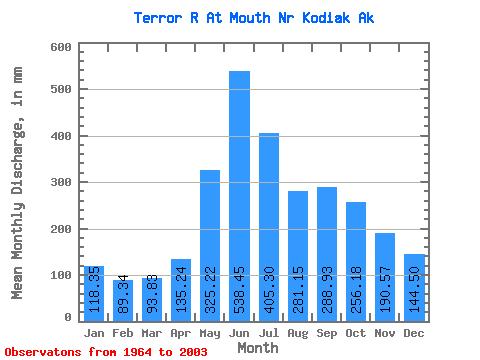
| Statistic | Jan | Feb | Mar | Apr | May | Jun | Jul | Aug | Sep | Oct | Nov | Dec | Annual |
|---|---|---|---|---|---|---|---|---|---|---|---|---|---|
| Mean | 118.35 | 90.12 | 93.82 | 135.25 | 325.16 | 538.46 | 405.23 | 281.11 | 288.92 | 256.14 | 190.57 | 144.47 | 2856.88 |
| Standard Deviation | 49.69 | 35.35 | 39.51 | 48.01 | 109.22 | 213.79 | 217.94 | 116.40 | 136.78 | 68.45 | 118.19 | 76.09 | 610.32 |
| Min | 36.89 | 23.56 | 26.15 | 45.73 | 190.87 | 281.56 | 185.10 | 161.08 | 146.12 | 120.44 | 61.80 | 46.21 | 1986.03 |
| Max | 254.28 | 178.54 | 190.25 | 228.28 | 708.88 | 1129.33 | 1046.00 | 631.86 | 653.28 | 406.84 | 582.13 | 342.56 | 4828.05 |
| Coefficient of Variation | 0.42 | 0.39 | 0.42 | 0.35 | 0.34 | 0.40 | 0.54 | 0.41 | 0.47 | 0.27 | 0.62 | 0.53 | 0.21 |
 Return to R-Arctic Net Home Page