|
|
|||||||||||||||||
| Point ID: 9502 | Downloads | Plots | Site Data | Code: 15295700 |
|
|
|||||||||||||||||
| Download | |
|---|---|
| Site Descriptor Information | Site Time Series Data |
| Link to all available data | |
| View: | Time Series | All |
| Units: | mm |
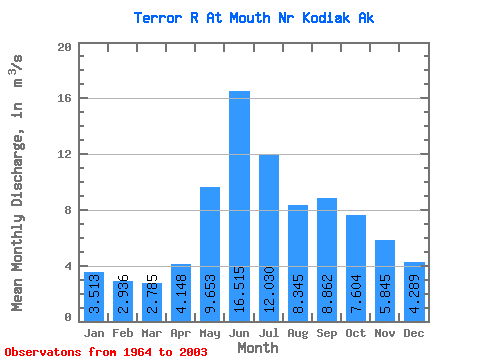
| Statistic | Jan | Feb | Mar | Apr | May | Jun | Jul | Aug | Sep | Oct | Nov | Dec | Annual |
|---|---|---|---|---|---|---|---|---|---|---|---|---|---|
| Mean | 3.51 | 2.94 | 2.79 | 4.15 | 9.65 | 16.52 | 12.03 | 8.35 | 8.86 | 7.60 | 5.84 | 4.29 | 7.20 |
| Standard Deviation | 1.48 | 1.15 | 1.17 | 1.47 | 3.24 | 6.56 | 6.47 | 3.46 | 4.20 | 2.03 | 3.62 | 2.26 | 1.54 |
| Min | 1.09 | 0.77 | 0.78 | 1.40 | 5.67 | 8.64 | 5.50 | 4.78 | 4.48 | 3.58 | 1.90 | 1.37 | 5.00 |
| Max | 7.55 | 5.82 | 5.65 | 7.00 | 21.04 | 34.64 | 31.05 | 18.76 | 20.04 | 12.08 | 17.86 | 10.17 | 12.16 |
| Coefficient of Variation | 0.42 | 0.39 | 0.42 | 0.35 | 0.34 | 0.40 | 0.54 | 0.41 | 0.47 | 0.27 | 0.62 | 0.53 | 0.21 |
 Return to R-Arctic Net Home Page