|
|
|||||||||||||||||
| Point ID: 9502 | Downloads | Plots | Site Data | Code: 15295700 |
|
|
|||||||||||||||||
| Download | |
|---|---|
| Site Descriptor Information | Site Time Series Data |
| Link to all available data | |
|
|
| View: | Statistics | Time Series |
| Units: | m3/s |
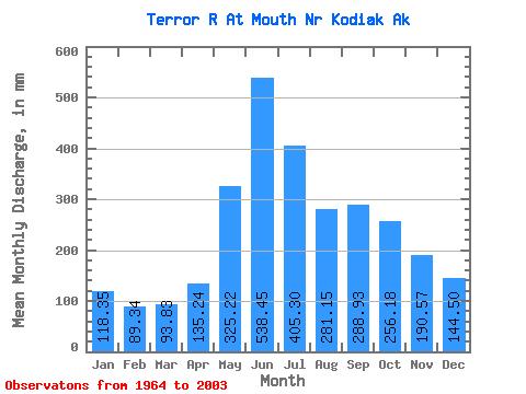
| Statistic | Jan | Feb | Mar | Apr | May | Jun | Jul | Aug | Sep | Oct | Nov | Dec | Annual |
|---|---|---|---|---|---|---|---|---|---|---|---|---|---|
| Mean | 118.35 | 90.12 | 93.82 | 135.25 | 325.16 | 538.46 | 405.23 | 281.11 | 288.92 | 256.14 | 190.57 | 144.47 | 2856.88 |
| Standard Deviation | 49.69 | 35.35 | 39.51 | 48.01 | 109.22 | 213.79 | 217.94 | 116.40 | 136.78 | 68.45 | 118.19 | 76.09 | 610.32 |
| Min | 36.89 | 23.56 | 26.15 | 45.73 | 190.87 | 281.56 | 185.10 | 161.08 | 146.12 | 120.44 | 61.80 | 46.21 | 1986.03 |
| Max | 254.28 | 178.54 | 190.25 | 228.28 | 708.88 | 1129.33 | 1046.00 | 631.86 | 653.28 | 406.84 | 582.13 | 342.56 | 4828.05 |
| Coefficient of Variation | 0.42 | 0.39 | 0.42 | 0.35 | 0.34 | 0.40 | 0.54 | 0.41 | 0.47 | 0.27 | 0.62 | 0.53 | 0.21 |
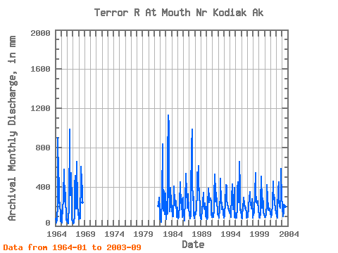
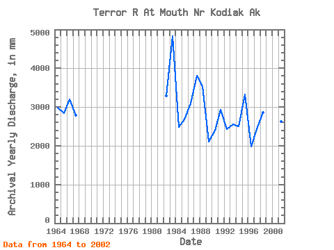
| Year | Jan | Feb | Mar | Apr | May | Jun | Jul | Aug | Sep | Oct | Nov | Dec | Annual | 1964 | 79.16 | 44.47 | 31.29 | 66.69 | 225.14 | 902.64 | 496.52 | 508.38 | 229.91 | 251.42 | 101.46 | 49.14 | 2979.37 | 1965 | 46.74 | 29.21 | 156.40 | 123.59 | 321.64 | 566.37 | 596.64 | 254.19 | 341.72 | 311.95 | 61.80 | 46.21 | 2843.66 | 1966 | 72.83 | 38.18 | 26.15 | 68.17 | 190.87 | 983.89 | 587.91 | 318.50 | 542.77 | 254.59 | 68.53 | 47.91 | 3200.80 | 1967 | 36.89 | 23.56 | 30.83 | 104.85 | 431.02 | 510.21 | 185.10 | 231.67 | 653.28 | 239.14 | 193.70 | 146.62 | 2786.84 | 1968 | 72.22 | 123.41 | 83.27 | 72.17 | 503.86 | 609.16 | 472.24 | 388.41 | 242.54 | 1981 | 211.06 | 292.11 | 168.04 | 1982 | 68.19 | 134.37 | 40.89 | 45.73 | 300.35 | 832.05 | 601.49 | 161.08 | 352.62 | 120.44 | 279.28 | 342.56 | 3282.34 | 1983 | 173.48 | 64.22 | 158.83 | 122.42 | 708.88 | 1129.33 | 1046.00 | 439.21 | 146.12 | 230.95 | 387.67 | 243.54 | 4828.05 | 1984 | 197.17 | 93.50 | 190.25 | 93.80 | 328.35 | 404.81 | 249.95 | 213.36 | 262.87 | 263.39 | 99.71 | 90.53 | 2480.10 | 1985 | 198.83 | 79.71 | 78.58 | 89.46 | 228.62 | 444.57 | 420.63 | 240.71 | 274.63 | 249.79 | 87.12 | 298.22 | 2679.47 | 1986 | 118.62 | 130.30 | 58.06 | 105.77 | 244.65 | 535.26 | 503.40 | 397.42 | 183.94 | 335.67 | 326.74 | 161.45 | 3095.69 | 1987 | 142.71 | 109.38 | 81.11 | 110.14 | 327.18 | 804.66 | 1020.87 | 462.85 | 261.86 | 304.50 | 121.56 | 74.77 | 3805.88 | 1988 | 146.03 | 114.09 | 130.68 | 173.10 | 346.22 | 551.08 | 375.76 | 631.86 | 442.32 | 340.62 | 180.64 | 120.37 | 3543.93 | 1989 | 78.00 | 63.10 | 93.94 | 152.42 | 253.08 | 343.66 | 217.78 | 182.80 | 190.47 | 240.16 | 97.93 | 205.76 | 2112.74 | 1990 | 85.75 | 67.26 | 92.74 | 208.22 | 393.88 | 281.56 | 248.60 | 284.07 | 283.37 | 255.85 | 116.39 | 92.19 | 2402.10 | 1991 | 135.26 | 102.09 | 90.56 | 169.63 | 318.29 | 528.64 | 360.84 | 252.34 | 337.26 | 231.05 | 284.32 | 118.59 | 2929.16 | 1992 | 120.19 | 79.86 | 97.42 | 155.26 | 352.19 | 485.75 | 237.99 | 245.45 | 165.72 | 204.50 | 147.69 | 139.70 | 2426.86 | 1993 | 85.05 | 90.73 | 132.96 | 228.28 | 432.87 | 412.69 | 258.13 | 243.82 | 172.24 | 201.88 | 153.72 | 141.33 | 2548.12 | 1994 | 135.02 | 145.76 | 90.80 | 131.47 | 294.50 | 427.86 | 261.80 | 174.72 | 257.98 | 406.84 | 86.60 | 81.76 | 2493.82 | 1995 | 135.23 | 97.77 | 85.08 | 182.74 | 392.16 | 449.92 | 340.02 | 250.62 | 652.94 | 405.30 | 160.68 | 170.72 | 3320.13 | 1996 | 81.72 | 77.74 | 79.84 | 219.02 | 238.07 | 290.11 | 225.53 | 180.16 | 204.37 | 185.36 | 122.64 | 82.40 | 1986.03 | 1997 | 122.00 | 103.86 | 91.17 | 196.19 | 295.11 | 345.20 | 274.84 | 220.89 | 235.76 | 182.90 | 272.88 | 81.54 | 2423.08 | 1998 | 100.62 | 104.13 | 145.23 | 146.08 | 345.15 | 544.06 | 365.12 | 245.18 | 241.89 | 218.00 | 252.59 | 157.39 | 2862.66 | 1999 | 124.19 | 82.72 | 85.11 | 128.61 | 240.40 | 506.24 | 257.56 | 187.94 | 280.20 | 230.43 | 131.75 | 124.80 | 2379.32 | 2000 | 93.54 | 82.74 | 100.56 | 118.57 | 232.50 | 417.03 | 293.54 | 187.76 | 161.48 | 187.51 | 171.54 | 168.90 | 2212.18 | 2001 | 138.22 | 84.05 | 91.11 | 121.37 | 232.87 | 457.74 | 382.70 | 275.08 | 289.00 | 250.59 | 173.63 | 139.02 | 2630.16 | 2002 | 153.57 | 88.56 | 87.57 | 167.57 | 380.63 | 449.12 | 268.34 | 204.50 | 182.31 | 345.83 | 582.13 | 262.77 | 3169.51 | 2003 | 254.28 | 178.54 | 102.77 | 150.30 | 220.77 | 324.86 | 392.03 | 206.96 | 211.36 |
|---|
 Return to R-Arctic Net Home Page