|
|
|||||||||||||||||
| Point ID: 9472 | Downloads | Plots | Site Data | Code: 15248000 |
|
|
|||||||||||||||||
| Download | |
|---|---|
| Site Descriptor Information | Site Time Series Data |
| Link to all available data | |
| View: | Time Series | All |
| Units: | m3/s |
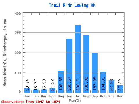
| Statistic | Jan | Feb | Mar | Apr | May | Jun | Jul | Aug | Sep | Oct | Nov | Dec | Annual |
|---|---|---|---|---|---|---|---|---|---|---|---|---|---|
| Mean | 23.74 | 16.10 | 15.98 | 24.22 | 108.33 | 268.66 | 336.66 | 286.94 | 197.05 | 104.89 | 62.58 | 37.31 | 1476.49 |
| Standard Deviation | 16.17 | 7.46 | 7.11 | 11.14 | 43.08 | 68.57 | 42.86 | 48.22 | 85.03 | 68.10 | 36.25 | 21.64 | 194.57 |
| Min | 11.09 | 8.32 | 8.97 | 9.63 | 34.12 | 166.50 | 277.55 | 165.02 | 97.01 | 42.10 | 22.16 | 13.72 | 1132.37 |
| Max | 93.56 | 39.47 | 38.27 | 48.00 | 239.00 | 470.79 | 434.45 | 394.17 | 456.65 | 386.42 | 145.05 | 97.56 | 1988.52 |
| Coefficient of Variation | 0.68 | 0.46 | 0.45 | 0.46 | 0.40 | 0.26 | 0.13 | 0.17 | 0.43 | 0.65 | 0.58 | 0.58 | 0.13 |
 Return to R-Arctic Net Home Page