|
|
|||||||||||||||||
| Point ID: 9472 | Downloads | Plots | Site Data | Code: 15248000 |
|
|
|||||||||||||||||
| Download | |
|---|---|
| Site Descriptor Information | Site Time Series Data |
| Link to all available data | |
| View: | Time Series | All |
| Units: | mm |
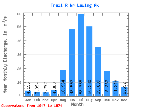
| Statistic | Jan | Feb | Mar | Apr | May | Jun | Jul | Aug | Sep | Oct | Nov | Dec | Annual |
|---|---|---|---|---|---|---|---|---|---|---|---|---|---|
| Mean | 4.16 | 3.09 | 2.80 | 4.38 | 18.96 | 48.59 | 58.94 | 50.23 | 35.64 | 18.36 | 11.32 | 6.53 | 21.93 |
| Standard Deviation | 2.83 | 1.43 | 1.25 | 2.02 | 7.54 | 12.40 | 7.50 | 8.44 | 15.38 | 11.92 | 6.56 | 3.79 | 2.89 |
| Min | 1.94 | 1.60 | 1.57 | 1.74 | 5.97 | 30.11 | 48.59 | 28.89 | 17.55 | 7.37 | 4.01 | 2.40 | 16.82 |
| Max | 16.38 | 7.58 | 6.70 | 8.68 | 41.84 | 85.15 | 76.05 | 69.00 | 82.59 | 67.64 | 26.23 | 17.08 | 29.54 |
| Coefficient of Variation | 0.68 | 0.46 | 0.45 | 0.46 | 0.40 | 0.26 | 0.13 | 0.17 | 0.43 | 0.65 | 0.58 | 0.58 | 0.13 |
 Return to R-Arctic Net Home Page