|
|
|||||||||||||||||
| Point ID: 9472 | Downloads | Plots | Site Data | Code: 15248000 |
|
|
|||||||||||||||||
| Download | |
|---|---|
| Site Descriptor Information | Site Time Series Data |
| Link to all available data | |
|
|
| View: | Statistics | Time Series |
| Units: | m3/s |
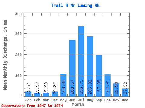
| Statistic | Jan | Feb | Mar | Apr | May | Jun | Jul | Aug | Sep | Oct | Nov | Dec | Annual |
|---|---|---|---|---|---|---|---|---|---|---|---|---|---|
| Mean | 23.74 | 16.10 | 15.98 | 24.22 | 108.33 | 268.66 | 336.66 | 286.94 | 197.05 | 104.89 | 62.58 | 37.31 | 1476.49 |
| Standard Deviation | 16.17 | 7.46 | 7.11 | 11.14 | 43.08 | 68.57 | 42.86 | 48.22 | 85.03 | 68.10 | 36.25 | 21.64 | 194.57 |
| Min | 11.09 | 8.32 | 8.97 | 9.63 | 34.12 | 166.50 | 277.55 | 165.02 | 97.01 | 42.10 | 22.16 | 13.72 | 1132.37 |
| Max | 93.56 | 39.47 | 38.27 | 48.00 | 239.00 | 470.79 | 434.45 | 394.17 | 456.65 | 386.42 | 145.05 | 97.56 | 1988.52 |
| Coefficient of Variation | 0.68 | 0.46 | 0.45 | 0.46 | 0.40 | 0.26 | 0.13 | 0.17 | 0.43 | 0.65 | 0.58 | 0.58 | 0.13 |
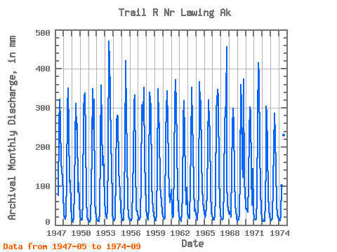
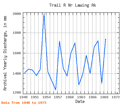
| Year | Jan | Feb | Mar | Apr | May | Jun | Jul | Aug | Sep | Oct | Nov | Dec | Annual | 1947 | 78.52 | 249.51 | 331.66 | 270.61 | 156.25 | 146.99 | 118.21 | 87.80 | 1948 | 26.97 | 19.34 | 15.47 | 27.46 | 122.56 | 296.17 | 362.81 | 249.06 | 110.45 | 117.90 | 48.63 | 18.56 | 1407.57 | 1949 | 11.19 | 8.32 | 11.25 | 16.32 | 94.06 | 217.88 | 321.69 | 251.98 | 258.46 | 88.60 | 108.75 | 59.18 | 1442.13 | 1950 | 20.98 | 13.15 | 13.52 | 14.13 | 66.26 | 296.71 | 337.04 | 349.35 | 225.30 | 69.00 | 22.16 | 13.72 | 1434.92 | 1951 | 11.52 | 8.49 | 8.97 | 17.17 | 87.88 | 201.55 | 359.21 | 254.90 | 320.96 | 58.33 | 34.44 | 21.75 | 1379.85 | 1952 | 13.22 | 10.76 | 11.04 | 9.63 | 34.12 | 202.72 | 369.17 | 262.77 | 152.75 | 183.07 | 134.19 | 64.28 | 1439.08 | 1953 | 33.81 | 21.98 | 16.92 | 41.94 | 188.37 | 470.79 | 432.89 | 350.23 | 195.66 | 174.04 | 45.56 | 25.46 | 1988.52 | 1954 | 18.85 | 13.27 | 12.39 | 18.09 | 134.72 | 263.99 | 290.59 | 288.04 | 146.39 | 109.15 | 90.83 | 38.63 | 1417.58 | 1955 | 23.65 | 13.29 | 11.69 | 12.70 | 70.36 | 201.59 | 434.45 | 285.37 | 191.18 | 54.06 | 24.89 | 15.89 | 1330.44 | 1956 | 14.61 | 11.22 | 11.45 | 18.55 | 96.41 | 169.55 | 321.59 | 344.34 | 150.88 | 42.10 | 34.99 | 33.97 | 1240.54 | 1957 | 16.60 | 13.49 | 16.00 | 23.68 | 116.15 | 307.33 | 277.55 | 286.31 | 352.89 | 159.99 | 114.14 | 39.06 | 1719.61 | 1958 | 30.43 | 16.79 | 14.65 | 48.00 | 124.06 | 340.27 | 328.53 | 314.86 | 105.54 | 67.72 | 41.29 | 26.61 | 1451.64 | 1959 | 17.61 | 12.40 | 12.12 | 27.02 | 150.52 | 348.67 | 285.79 | 253.49 | 97.01 | 83.62 | 57.28 | 35.87 | 1375.11 | 1960 | 23.11 | 18.98 | 15.30 | 19.80 | 239.00 | 295.49 | 353.99 | 273.79 | 154.43 | 86.30 | 58.81 | 72.64 | 1601.78 | 1961 | 93.56 | 35.88 | 19.14 | 23.42 | 167.91 | 311.25 | 384.72 | 313.03 | 212.81 | 80.50 | 45.12 | 22.02 | 1701.47 | 1962 | 17.73 | 12.45 | 10.73 | 32.11 | 81.94 | 267.12 | 328.27 | 239.46 | 120.47 | 54.09 | 95.15 | 33.94 | 1288.23 | 1963 | 19.84 | 17.52 | 21.84 | 17.24 | 104.08 | 203.93 | 363.75 | 268.10 | 201.50 | 99.08 | 36.34 | 42.41 | 1387.27 | 1964 | 28.28 | 18.71 | 14.24 | 47.43 | 78.91 | 365.99 | 324.46 | 329.47 | 170.21 | 98.29 | 62.55 | 43.84 | 1576.86 | 1965 | 34.21 | 17.18 | 25.95 | 47.60 | 80.36 | 211.28 | 330.61 | 273.95 | 239.25 | 90.06 | 30.84 | 24.98 | 1399.96 | 1966 | 19.86 | 13.15 | 14.24 | 23.45 | 75.68 | 295.47 | 327.59 | 358.22 | 326.00 | 130.07 | 57.70 | 26.82 | 1662.50 | 1967 | 17.32 | 14.42 | 14.27 | 16.87 | 105.28 | 264.80 | 295.81 | 330.88 | 456.65 | 114.75 | 52.03 | 40.98 | 1720.31 | 1968 | 30.75 | 25.90 | 36.39 | 21.05 | 149.08 | 247.53 | 307.92 | 261.53 | 124.10 | 49.53 | 37.53 | 18.89 | 1303.22 | 1969 | 11.09 | 12.69 | 14.43 | 29.20 | 133.22 | 359.84 | 315.90 | 165.02 | 122.37 | 386.42 | 97.72 | 97.56 | 1735.22 | 1970 | 43.98 | 39.47 | 38.27 | 33.23 | 114.68 | 234.95 | 312.61 | 299.10 | 132.45 | 53.03 | 145.05 | 37.39 | 1479.17 | 1971 | 17.95 | 13.54 | 14.62 | 15.08 | 69.11 | 277.32 | 427.82 | 394.17 | 194.87 | 96.81 | 33.13 | 21.37 | 1565.80 | 1972 | 12.55 | 8.89 | 11.52 | 10.15 | 59.31 | 166.50 | 313.13 | 296.64 | 192.51 | 84.32 | 36.52 | 23.16 | 1207.49 | 1973 | 15.69 | 11.79 | 12.99 | 18.73 | 106.28 | 201.63 | 295.39 | 232.29 | 143.47 | 54.24 | 25.73 | 20.74 | 1132.37 | 1974 | 15.54 | 11.73 | 12.03 | 23.82 | 104.52 | 252.75 | 291.58 | 237.25 | 262.63 |
|---|
 Return to R-Arctic Net Home Page