|
|
|||||||||||||||||
| Point ID: 9455 | Downloads | Plots | Site Data | Code: 15242000 |
|
|
|||||||||||||||||
| Download | |
|---|---|
| Site Descriptor Information | Site Time Series Data |
| Link to all available data | |
| View: | Time Series | All |
| Units: | m3/s |
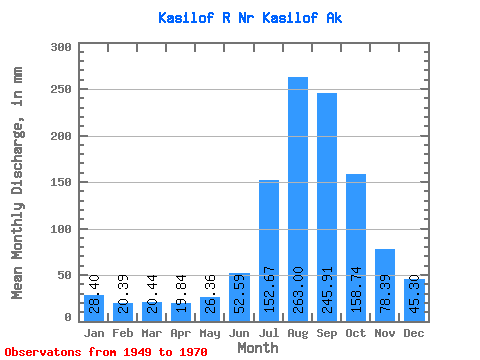
| Statistic | Jan | Feb | Mar | Apr | May | Jun | Jul | Aug | Sep | Oct | Nov | Dec | Annual |
|---|---|---|---|---|---|---|---|---|---|---|---|---|---|
| Mean | 28.39 | 20.57 | 20.44 | 19.84 | 26.35 | 52.59 | 152.65 | 262.96 | 245.91 | 158.72 | 78.39 | 45.29 | 1118.31 |
| Standard Deviation | 9.91 | 7.39 | 7.20 | 5.56 | 5.30 | 11.96 | 35.25 | 54.97 | 59.74 | 36.15 | 24.44 | 16.29 | 166.24 |
| Min | 11.51 | 10.12 | 10.71 | 4.34 | 10.47 | 31.65 | 83.02 | 165.36 | 152.92 | 102.53 | 44.56 | 14.22 | 837.47 |
| Max | 45.88 | 34.53 | 36.48 | 27.59 | 38.91 | 69.91 | 218.73 | 397.76 | 402.49 | 233.47 | 142.30 | 74.82 | 1492.46 |
| Coefficient of Variation | 0.35 | 0.36 | 0.35 | 0.28 | 0.20 | 0.23 | 0.23 | 0.21 | 0.24 | 0.23 | 0.31 | 0.36 | 0.15 |
 Return to R-Arctic Net Home Page