|
|
|||||||||||||||||
| Point ID: 9455 | Downloads | Plots | Site Data | Code: 15242000 |
|
|
|||||||||||||||||
| Download | |
|---|---|
| Site Descriptor Information | Site Time Series Data |
| Link to all available data | |
| View: | Time Series | All |
| Units: | mm |
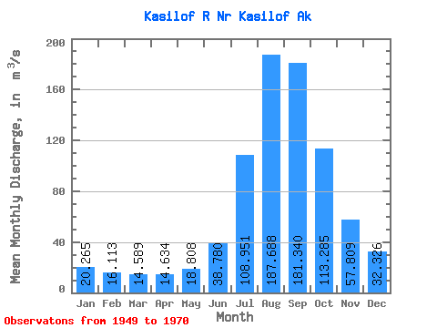
| Statistic | Jan | Feb | Mar | Apr | May | Jun | Jul | Aug | Sep | Oct | Nov | Dec | Annual |
|---|---|---|---|---|---|---|---|---|---|---|---|---|---|
| Mean | 20.27 | 16.11 | 14.59 | 14.63 | 18.81 | 38.78 | 108.95 | 187.69 | 181.34 | 113.28 | 57.81 | 32.33 | 67.73 |
| Standard Deviation | 7.08 | 5.79 | 5.14 | 4.10 | 3.79 | 8.82 | 25.16 | 39.23 | 44.05 | 25.80 | 18.02 | 11.62 | 10.07 |
| Min | 8.21 | 7.93 | 7.65 | 3.20 | 7.47 | 23.34 | 59.26 | 118.03 | 112.77 | 73.18 | 32.86 | 10.15 | 50.72 |
| Max | 32.75 | 27.05 | 26.04 | 20.35 | 27.77 | 51.56 | 156.12 | 283.90 | 296.81 | 166.64 | 104.93 | 53.40 | 90.39 |
| Coefficient of Variation | 0.35 | 0.36 | 0.35 | 0.28 | 0.20 | 0.23 | 0.23 | 0.21 | 0.24 | 0.23 | 0.31 | 0.36 | 0.15 |
 Return to R-Arctic Net Home Page