|
|
|||||||||||||||||
| Point ID: 9455 | Downloads | Plots | Site Data | Code: 15242000 |
|
|
|||||||||||||||||
| Download | |
|---|---|
| Site Descriptor Information | Site Time Series Data |
| Link to all available data | |
|
|
| View: | Statistics | Time Series |
| Units: | m3/s |
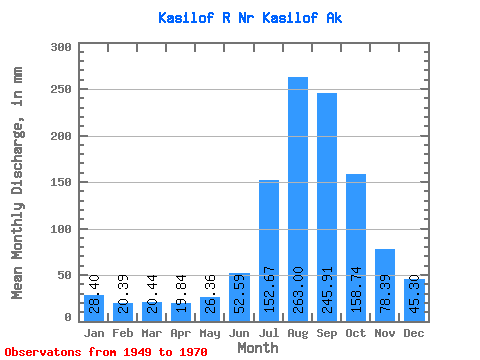
| Statistic | Jan | Feb | Mar | Apr | May | Jun | Jul | Aug | Sep | Oct | Nov | Dec | Annual |
|---|---|---|---|---|---|---|---|---|---|---|---|---|---|
| Mean | 28.39 | 20.57 | 20.44 | 19.84 | 26.35 | 52.59 | 152.65 | 262.96 | 245.91 | 158.72 | 78.39 | 45.29 | 1118.31 |
| Standard Deviation | 9.91 | 7.39 | 7.20 | 5.56 | 5.30 | 11.96 | 35.25 | 54.97 | 59.74 | 36.15 | 24.44 | 16.29 | 166.24 |
| Min | 11.51 | 10.12 | 10.71 | 4.34 | 10.47 | 31.65 | 83.02 | 165.36 | 152.92 | 102.53 | 44.56 | 14.22 | 837.47 |
| Max | 45.88 | 34.53 | 36.48 | 27.59 | 38.91 | 69.91 | 218.73 | 397.76 | 402.49 | 233.47 | 142.30 | 74.82 | 1492.46 |
| Coefficient of Variation | 0.35 | 0.36 | 0.35 | 0.28 | 0.20 | 0.23 | 0.23 | 0.21 | 0.24 | 0.23 | 0.31 | 0.36 | 0.15 |
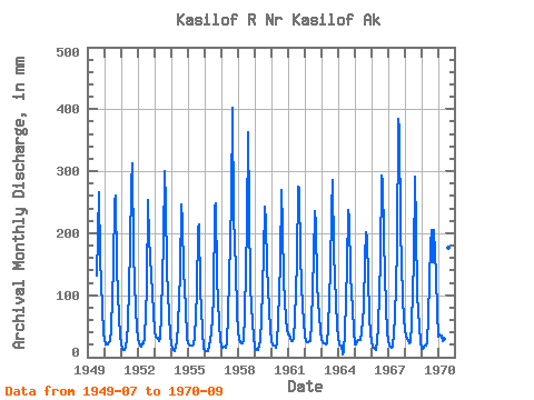
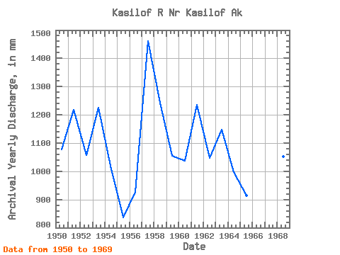
| Year | Jan | Feb | Mar | Apr | May | Jun | Jul | Aug | Sep | Oct | Nov | Dec | Annual | 1949 | 135.38 | 204.47 | 266.81 | 164.66 | 80.55 | 39.67 | 1950 | 29.76 | 19.88 | 21.03 | 24.91 | 26.24 | 45.38 | 150.16 | 258.43 | 260.35 | 148.35 | 63.04 | 35.58 | 1078.42 | 1951 | 21.25 | 13.01 | 11.49 | 17.41 | 27.87 | 52.37 | 181.42 | 287.20 | 312.52 | 172.25 | 77.66 | 49.02 | 1217.78 | 1952 | 33.21 | 21.04 | 18.39 | 21.85 | 23.44 | 31.65 | 115.05 | 262.74 | 190.88 | 167.54 | 103.08 | 74.82 | 1057.97 | 1953 | 43.51 | 31.91 | 31.52 | 25.70 | 30.60 | 69.91 | 194.40 | 309.84 | 247.74 | 144.84 | 67.43 | 35.58 | 1227.33 | 1954 | 22.22 | 13.74 | 11.11 | 16.89 | 27.57 | 53.38 | 139.22 | 254.17 | 217.53 | 144.96 | 79.00 | 32.36 | 1007.28 | 1955 | 23.80 | 19.52 | 19.04 | 19.41 | 21.70 | 32.41 | 106.38 | 213.64 | 213.54 | 112.34 | 44.56 | 14.22 | 837.47 | 1956 | 11.51 | 10.12 | 10.71 | 17.25 | 29.48 | 38.87 | 97.66 | 250.78 | 248.93 | 131.94 | 55.35 | 28.78 | 927.39 | 1957 | 17.99 | 14.51 | 16.98 | 15.89 | 24.80 | 68.75 | 192.62 | 262.59 | 402.49 | 233.47 | 142.30 | 73.08 | 1461.11 | 1958 | 45.43 | 25.99 | 22.67 | 22.29 | 26.02 | 69.81 | 218.73 | 375.31 | 238.35 | 117.34 | 54.73 | 33.62 | 1242.94 | 1959 | 16.42 | 11.36 | 11.33 | 18.98 | 28.46 | 59.76 | 171.02 | 250.72 | 218.55 | 150.95 | 78.22 | 44.50 | 1054.59 | 1960 | 26.26 | 18.96 | 18.62 | 15.47 | 22.62 | 60.52 | 157.06 | 278.87 | 211.10 | 127.06 | 62.36 | 45.15 | 1038.53 | 1961 | 37.75 | 34.53 | 27.50 | 25.84 | 32.09 | 60.47 | 161.06 | 283.44 | 270.98 | 168.32 | 79.99 | 59.51 | 1236.78 | 1962 | 36.50 | 24.58 | 24.60 | 25.90 | 26.84 | 53.77 | 168.49 | 243.93 | 215.50 | 119.91 | 67.88 | 44.82 | 1048.01 | 1963 | 28.42 | 22.02 | 22.47 | 19.96 | 23.45 | 49.10 | 145.04 | 242.96 | 286.54 | 172.66 | 89.39 | 51.32 | 1149.29 | 1964 | 32.83 | 19.39 | 19.41 | 4.34 | 10.47 | 37.83 | 150.15 | 245.77 | 224.89 | 135.71 | 77.35 | 45.71 | 998.94 | 1965 | 22.17 | 19.16 | 29.60 | 27.59 | 27.85 | 39.87 | 83.02 | 165.36 | 202.37 | 196.53 | 67.48 | 38.66 | 916.01 | 1966 | 26.68 | 15.75 | 13.18 | 11.88 | 26.02 | 49.18 | 162.74 | 303.04 | 283.70 | 197.60 | 79.95 | 41.59 | 1204.95 | 1967 | 26.43 | 17.74 | 15.82 | 17.53 | 38.91 | 64.05 | 181.13 | 397.76 | 368.41 | 212.99 | 95.76 | 63.35 | 1492.46 | 1968 | 45.88 | 31.36 | 27.76 | 22.94 | 25.75 | 55.08 | 159.66 | 301.28 | 211.44 | 102.53 | 48.47 | 25.20 | 1052.40 | 1969 | 13.87 | 13.40 | 19.53 | 18.74 | 23.05 | 65.42 | 187.45 | 211.41 | 152.92 | 211.18 | 131.72 | 74.59 | 1116.45 | 1970 | 34.35 | 33.95 | 36.48 | 25.97 | 30.17 | 46.77 | 100.40 | 181.49 | 164.49 |
|---|
 Return to R-Arctic Net Home Page