|
|
|||||||||||||||||
| Point ID: 9437 | Downloads | Plots | Site Data | Code: 15271000 |
|
|
|||||||||||||||||
| Download | |
|---|---|
| Site Descriptor Information | Site Time Series Data |
| Link to all available data | |
| View: | Time Series | All |
| Units: | m3/s |
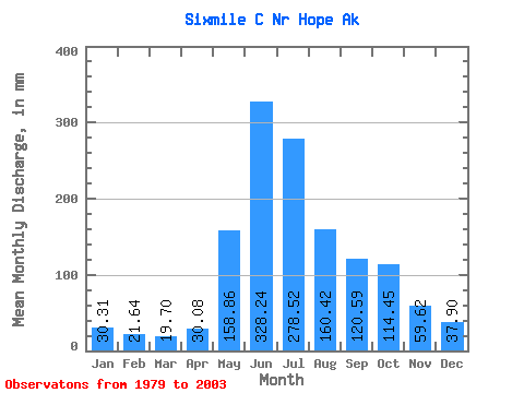
| Statistic | Jan | Feb | Mar | Apr | May | Jun | Jul | Aug | Sep | Oct | Nov | Dec | Annual |
|---|---|---|---|---|---|---|---|---|---|---|---|---|---|
| Mean | 30.31 | 21.83 | 19.70 | 30.08 | 158.83 | 328.24 | 278.47 | 160.40 | 120.58 | 114.43 | 59.62 | 37.89 | 1384.45 |
| Standard Deviation | 13.81 | 9.28 | 5.24 | 10.85 | 39.13 | 73.92 | 89.17 | 60.25 | 35.02 | 52.12 | 41.38 | 14.94 | 279.92 |
| Min | 16.67 | 12.91 | 13.32 | 14.39 | 93.61 | 210.22 | 145.87 | 95.06 | 53.23 | 62.53 | 26.80 | 24.72 | 1040.22 |
| Max | 66.07 | 49.34 | 30.01 | 48.03 | 226.56 | 479.22 | 498.77 | 337.73 | 188.45 | 222.28 | 210.11 | 85.98 | 1949.13 |
| Coefficient of Variation | 0.46 | 0.42 | 0.27 | 0.36 | 0.25 | 0.23 | 0.32 | 0.38 | 0.29 | 0.46 | 0.69 | 0.39 | 0.20 |
 Return to R-Arctic Net Home Page