|
|
|||||||||||||||||
| Point ID: 9437 | Downloads | Plots | Site Data | Code: 15271000 |
|
|
|||||||||||||||||
| Download | |
|---|---|
| Site Descriptor Information | Site Time Series Data |
| Link to all available data | |
| View: | Time Series | All |
| Units: | mm |
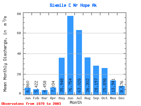
| Statistic | Jan | Feb | Mar | Apr | May | Jun | Jul | Aug | Sep | Oct | Nov | Dec | Annual |
|---|---|---|---|---|---|---|---|---|---|---|---|---|---|
| Mean | 6.86 | 5.42 | 4.46 | 7.03 | 35.95 | 76.75 | 63.03 | 36.30 | 28.20 | 25.90 | 13.94 | 8.58 | 26.59 |
| Standard Deviation | 3.12 | 2.31 | 1.19 | 2.54 | 8.86 | 17.29 | 20.18 | 13.63 | 8.19 | 11.79 | 9.68 | 3.38 | 5.38 |
| Min | 3.77 | 3.21 | 3.02 | 3.37 | 21.18 | 49.16 | 33.02 | 21.51 | 12.45 | 14.15 | 6.27 | 5.59 | 19.98 |
| Max | 14.95 | 12.26 | 6.79 | 11.23 | 51.27 | 112.06 | 112.88 | 76.44 | 44.07 | 50.31 | 49.13 | 19.46 | 37.43 |
| Coefficient of Variation | 0.46 | 0.42 | 0.27 | 0.36 | 0.25 | 0.23 | 0.32 | 0.38 | 0.29 | 0.46 | 0.69 | 0.39 | 0.20 |
 Return to R-Arctic Net Home Page