|
|
|||||||||||||||||
| Point ID: 9437 | Downloads | Plots | Site Data | Code: 15271000 |
|
|
|||||||||||||||||
| Download | |
|---|---|
| Site Descriptor Information | Site Time Series Data |
| Link to all available data | |
|
|
| View: | Statistics | Time Series |
| Units: | m3/s |
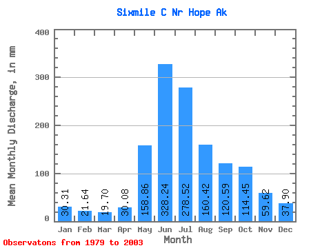
| Statistic | Jan | Feb | Mar | Apr | May | Jun | Jul | Aug | Sep | Oct | Nov | Dec | Annual |
|---|---|---|---|---|---|---|---|---|---|---|---|---|---|
| Mean | 30.31 | 21.83 | 19.70 | 30.08 | 158.83 | 328.24 | 278.47 | 160.40 | 120.58 | 114.43 | 59.62 | 37.89 | 1384.45 |
| Standard Deviation | 13.81 | 9.28 | 5.24 | 10.85 | 39.13 | 73.92 | 89.17 | 60.25 | 35.02 | 52.12 | 41.38 | 14.94 | 279.92 |
| Min | 16.67 | 12.91 | 13.32 | 14.39 | 93.61 | 210.22 | 145.87 | 95.06 | 53.23 | 62.53 | 26.80 | 24.72 | 1040.22 |
| Max | 66.07 | 49.34 | 30.01 | 48.03 | 226.56 | 479.22 | 498.77 | 337.73 | 188.45 | 222.28 | 210.11 | 85.98 | 1949.13 |
| Coefficient of Variation | 0.46 | 0.42 | 0.27 | 0.36 | 0.25 | 0.23 | 0.32 | 0.38 | 0.29 | 0.46 | 0.69 | 0.39 | 0.20 |
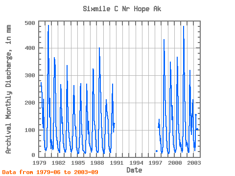
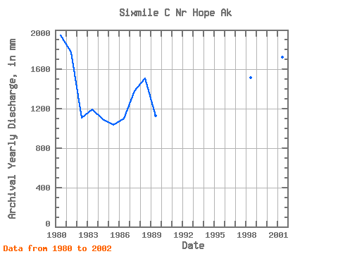
| Year | Jan | Feb | Mar | Apr | May | Jun | Jul | Aug | Sep | Oct | Nov | Dec | Annual | 1979 | 273.92 | 233.72 | 140.49 | 109.20 | 219.14 | 79.24 | 43.19 | 1980 | 28.81 | 27.84 | 24.43 | 39.97 | 178.67 | 435.91 | 498.77 | 248.58 | 147.19 | 222.28 | 74.71 | 31.68 | 1949.13 | 1981 | 66.07 | 34.84 | 29.42 | 32.12 | 226.56 | 364.42 | 362.31 | 337.73 | 140.19 | 82.92 | 67.96 | 39.15 | 1774.77 | 1982 | 27.73 | 24.13 | 18.57 | 17.76 | 101.08 | 266.01 | 241.35 | 129.40 | 148.42 | 63.74 | 35.88 | 34.89 | 1106.66 | 1983 | 23.88 | 17.75 | 19.28 | 32.87 | 166.44 | 336.81 | 231.26 | 148.14 | 73.55 | 68.38 | 48.35 | 34.30 | 1197.20 | 1984 | 20.46 | 18.12 | 30.01 | 31.35 | 127.62 | 262.90 | 195.82 | 127.79 | 103.72 | 114.39 | 39.57 | 28.61 | 1096.65 | 1985 | 20.48 | 13.03 | 13.34 | 14.39 | 93.61 | 249.38 | 278.81 | 145.37 | 100.87 | 64.14 | 26.80 | 24.74 | 1040.22 | 1986 | 23.56 | 16.46 | 13.93 | 16.95 | 110.50 | 268.11 | 227.39 | 118.13 | 84.44 | 136.00 | 53.64 | 39.23 | 1103.83 | 1987 | 36.53 | 27.26 | 19.82 | 28.97 | 159.90 | 323.98 | 326.07 | 151.09 | 119.76 | 121.32 | 46.76 | 26.84 | 1382.95 | 1988 | 20.26 | 17.10 | 17.52 | 23.58 | 185.84 | 401.36 | 347.54 | 212.53 | 117.97 | 102.35 | 39.95 | 29.54 | 1509.01 | 1989 | 21.55 | 14.05 | 13.68 | 41.87 | 131.12 | 210.22 | 184.08 | 160.16 | 149.32 | 132.67 | 44.70 | 34.51 | 1133.42 | 1990 | 25.17 | 17.07 | 17.38 | 48.03 | 204.91 | 268.63 | 145.87 | 95.06 | 123.59 | 1997 | 22.28 | 113.81 | 138.04 | 62.53 | 69.03 | 25.95 | 1998 | 17.27 | 14.94 | 23.49 | 47.55 | 176.22 | 431.67 | 356.22 | 167.82 | 142.58 | 80.27 | 41.21 | 24.72 | 1519.69 | 1999 | 16.67 | 12.91 | 13.32 | 22.26 | 159.68 | 349.41 | 243.81 | 142.39 | 188.45 | 112.56 | 48.18 | 44.11 | 1350.53 | 2000 | 29.46 | 19.66 | 18.25 | 30.78 | 170.91 | 365.96 | 310.45 | 151.56 | 91.78 | 83.93 | 46.95 | 40.33 | 1354.97 | 2001 | 55.36 | 24.52 | 19.06 | 25.20 | 128.03 | 479.22 | 398.96 | 240.54 | 174.79 | 86.32 | 40.45 | 56.42 | 1723.70 | 2002 | 44.70 | 22.05 | 17.88 | 19.53 | 218.37 | 318.37 | 204.59 | 110.83 | 83.99 | 192.35 | 210.11 | 85.98 | 1524.05 | 2003 | 37.26 | 49.34 | 25.47 | 46.00 | 160.70 | 302.02 | 225.51 | 106.12 | 53.23 |
|---|
 Return to R-Arctic Net Home Page