|
|
|||||||||||||||||
| Point ID: 9419 | Downloads | Plots | Site Data | Code: 15635000 |
|
|
|||||||||||||||||
| Download | |
|---|---|
| Site Descriptor Information | Site Time Series Data |
| Link to all available data | |
| View: | Time Series | All |
| Units: | m3/s |
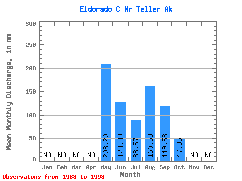
| Statistic | Jan | Feb | Mar | Apr | May | Jun | Jul | Aug | Sep | Oct | Nov | Dec | Annual |
|---|---|---|---|---|---|---|---|---|---|---|---|---|---|
| Mean | 208.23 | 128.37 | 88.57 | 160.54 | 119.65 | 47.82 | |||||||
| Standard Deviation | 128.01 | 125.59 | 50.15 | 113.49 | 45.74 | 34.80 | |||||||
| Min | 100.47 | 29.77 | 41.42 | 42.49 | 33.08 | 23.21 | |||||||
| Max | 465.08 | 421.30 | 200.31 | 437.88 | 172.57 | 72.42 | |||||||
| Coefficient of Variation | 0.61 | 0.98 | 0.57 | 0.71 | 0.38 | 0.73 |
 Return to R-Arctic Net Home Page